
 South
Canyon Fire South
Canyon Fire
1994
6 Minutes for Safety — 2009
Fire Behavior Report, 1998
Fire Environment
- July 2 to
Evening of July 5
- July
5, 2230 to July 6, 1530
- July 6, 1530
to 1600
- July 6, 1600
to 1603
- July
6, 1603 to 1609
- July 6, 1609
to 1610
- July 6, 1610
to 1611
- July 6, 1611
to 1614
- July 6, 1614
to 1623
- July
6, 1622 to 1830
- July
6, 1830 to July 11
References
Appendix A
Appendix B
Appendix C
|
 Fire
Behavior Associated with the 1994 South Canyon Fire on Storm King Mountain,
Colorado Fire
Behavior Associated with the 1994 South Canyon Fire on Storm King Mountain,
Colorado
Fire Chronology
One of our major objectives was to estimate fire spread rates during
the afternoon of July 6. This can be done using fire spread models or
by calculating the distance and time separating successive fire perimeters.
We chose the latter method; the original accident investigators used fire
behavior models. Our method of analysis required that we develop a chronological
history of the movement and location of individual firefighters. We used
witness statements, followup interviews, onsite reenactment of firefighter
movement, and calculations based on known physiological capabilities for
hotshots and smokejumpers (Sharkey 1994). From the chronology and witness
statements we constructed fire perimeter maps. These maps were then used
to estimate fire spread rates.
The following is a narrative of firefighter movements and fire behavior
on the South Canyon Fire for July 2 through July 6, 1994. Whenever possible,
we describe events in chronological order.
The location names are the same as those in the original fire investigation
report with some additional areas identified. Specific locations are identified
in figure 17, an oblique photograph, and figure 18, a labeled topographical
map. We use surnames when referring to individual firefighters. Some titles
are used. Full name and affiliation are available in the South Canyon
Fire investigation report.
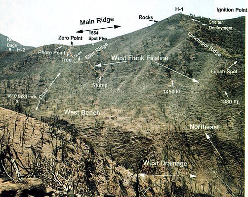
Figure 17—View looking northeast over West Flank from east-facing
ridge across the West Drainage. The West Flank Fireline can be seen starting
at the Main Ridge above the Tree and passing down the hill over the Spur
Ridge and across the slope to the Lunch Spot. J.
Kautz, U.S. Forest Service, Missoula, MT.
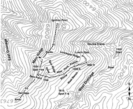
Figure 18—Topographical map showing locations important to narrative.
Map is oriented south to north for use with figure 17. Dashed lines indicate
firelines along West Flank and Main Ridge.
To make it easier for the reader to follow the chain of events surrounding
the fire, we regularly refer to four separate firefighter groups (see
table 1). These groups are identified by their general location at approximately
1530 hours on July 6. The groups are: (1) The Main Ridge Group, which
consisted of part of the Prineville Interagency Hotshot crew and a Bureau
of Land Management (BLM) and U.S. Forest Service crew dispatched from
Grand Junction, CO; they all worked primarily along the top of the Main
Ridge.
(2) The West Flank Fireline Group consisting of nine Prineville Hotshots,
seven Forest Service smokejumpers, and two BLM/USFS firefighters who worked
on the West Flank Fireline; three of the smokejumpers moved from the West
Flank Fireline to the Main Ridge before the entrapment. (3) The Lunch
Spot Ridge Group, nine Forest Service smokejumpers who were working primarily
south of the Lunch Spot Ridge in the area of the Double Draws just prior
to blowup; eight of this group eventually deployed in fire shelters on
the upper portion of the Lunch Spot Ridge, the ninth remained near the
Lunch Spot. (4) The two helitack crewmembers (one Forest Service and one
BLM) make up the fourth group. A helicopter pilot was over the fire a
portion of the time.
Table
1Personnel roster and position at time of blowup.
Main Ridge Group |
West Flank
Fireline Group |
Lunch Spot
Ridge Group |
Helitack Group |
Prineville Hotshots
Bill Baker
Kip Gray
Tony Johnson
Brian Lee
Louie Navarro
Tom Rambo
Alex Robertson
Bryan Scholz
Tom Shepard*
Mike Simmons
Kim Valentine
|
Prineville Hotshots
Kathi Beck
Tami Bickett
Scott Blecha
Levi Brinkley
Doug Dunbar
Terri Hagen
Bonnie Holtby
Rob Johnson
Jon Kelso |
Smokejumpers
Michael Cooper
Mike Feliciano
Dale Longanecker
Tony Petrilli
Quentin Rhoades
Eric Shelton
Sonny Soto
Bill Thomas
Keith Woods
|
Helitack
Robert Browning*
Richard Tyler* |
BLM/U.S. Forest Service
Todd Abbott
Butch Blanco*
Jim Byers
Eric Christianson
Mike Hayes
Loren Paulson
Brian Rush
Michelle Ryerson
Neal Shunk
|
Smokejumpers
Sonny Archuleta**
Sarah Doehring**
Kevin Erickson**
Eric Hipke
Don Mackey***
Roger Roth
Jim Thrash |
Helicopter Pilot
Dick Good |
Firefighters listed
in boldface type were killed on the South Canyon Fire.
*Positioned near H-2.
**Moved from West Flank Fireline to Main Ridge before the entrapment.
***Moved from Lunch Spot Ridge to West Flank Fireline.
Reconstruction of the fire position and spread rates required that we
accurately determine each group’s location and activity. Specific
times are included in the narrative to indicate the sequence of events
and to communicate the speed at which the events occurred. These times
were determined by linking elapsed times between events such as helicopter
ferry times, reenactment and timing of specific firefighter movements,
and human physiological calculations to two known clock times identified
in the witness statements. The times presented in the narrative represent
a “best fit estimate” and should not be taken as absolute.
When estimating fire spread rates, the sequencing and relative time differences
between events are of more importance than the absolute times. A great
deal of fire and crew activity occurred simultaneously among and between
the separate groups making chronological description of both the fire
behavior and firefighter positions difficult. We have attempted to divide
the narrative into geographical regions and have labeled paragraphs with
the central location or group being discussed. We include in the narrative
weather and fire behavior as described by firefighters at various locations.
The fire perimeters were developed from witness statements, time and
distance measurements and estimates, and topographical, weather, and fuel
information. Fire spread rates are estimated from elapsed times and distances
between successive fire perimeters. Tables of event times, distances,
firefighter travel rates, fire spread rates and reference sources are
included in appendix B.
<<< continue
reading—Fire Behavior at South Canyon Fire, Fire Chronology: July
2 >>>
|