Rocky Mountain Area Predictive
Services
2006 Preliminary Seasonal Fire Weather / Fire Danger
Outlook
April 13, 2006
B. Current Conditions and Comparisons with Historical Records
A comparison of the U.S. Drought Monitor to last year for about the same
time (Figures 2 and 3),
indicates much improved drought conditions across Wyoming and South Dakota.
In March of 2005, “Extreme” to “Exceptional” drought
conditions was noted over Wyoming and western South Dakota. However, precipitation
trends over the last 12 months have resulted in improved drought conditions
for that area with indices in the “Moderate” category. Elsewhere,
drought conditions have eased from “Severe” to “Moderate”
over Nebraska from a year ago, but have worsened from “Abnormally
Dry” to “Moderate” across eastern Colorado and Kansas.
Some improvement from “Moderate” to “Abnormally Dry”
occurred over western Colorado. Figures 4
and 5 show drought conditions for the
end of March 2004 and 2003, respectively.
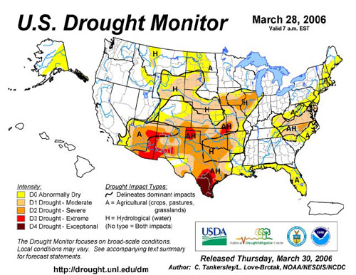
Figure 2. Drought Monitor
for March 28, 2006.
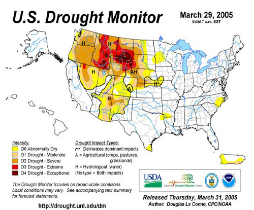
Figure 3. Drought Monitor for March 29, 2005.
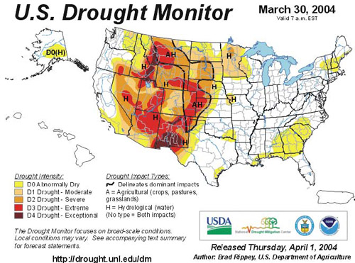
Figure 4. Drought Monitor for March 30, 2004.
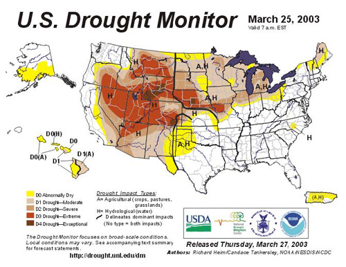
Figure 5. Drought Monitor for March 25, 2003.
Winter weather patterns brought above average snowpack to portions of
the Rocky Mountain Area (Figures 6 thru
11), including the northern and central
mountains of Colorado, and western and southern Wyoming mountains, near
average snowpack to the Black Hills, and northern San Juan’s of
Colorado, and below average snowpack to the southern San Juan’s,
Rio Grand Area of Colorado, and entire Front Range of Colorado generally
below 9,000 feet.
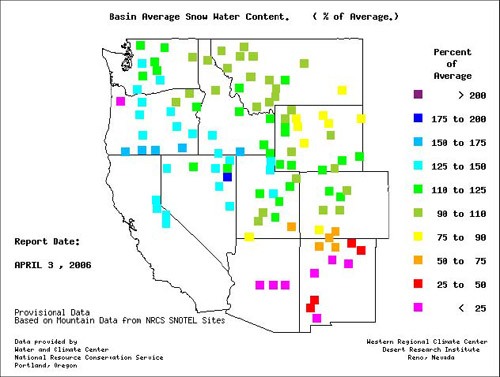
Figure 6. Basin average snow
water content as of April 3, 2006
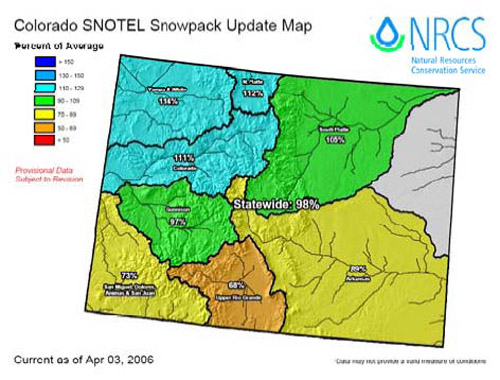
Figure 7. Colorado SNOTEL percent of average basin snowpack as of April
3, 2006.
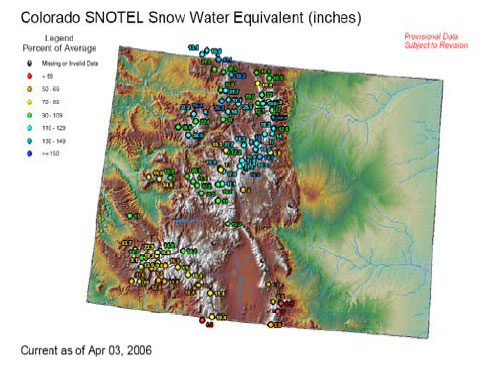
Figure 8. Colorado SNOTEL snow water equivalent as of April 3, 2006.
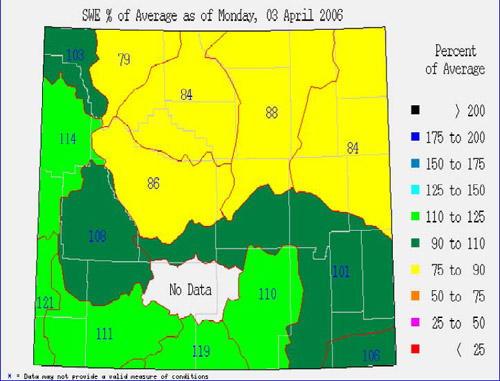
Figure 9. Wyoming percent of average snow water equivalent as of April
3, 2006
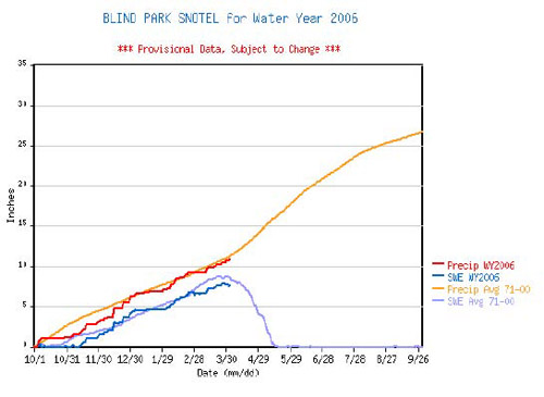
Figure 10. Blind Park SNOTEL for water year 2006. Percent of average snow
water equivalent as of April 3, 2006.
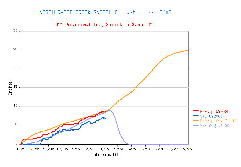
Figure 11. North Rapid Creek SNOTEL for water year 2006. Percent of average
snow water equivalent as of April 3, 2006.
Figure 12 shows percent of average
precipitation for the RMA for a 2-week period ending April 11, 2006. As
indicated by the graphic, percent of average precipitation is 25%- 50%
across portions of eastern Colorado, southeast/central Wyoming, western
Kansas, and central South Dakota. Figure 13,
90-day percent of normal precipitation ending April 11, 2006, shows similar
conditions.
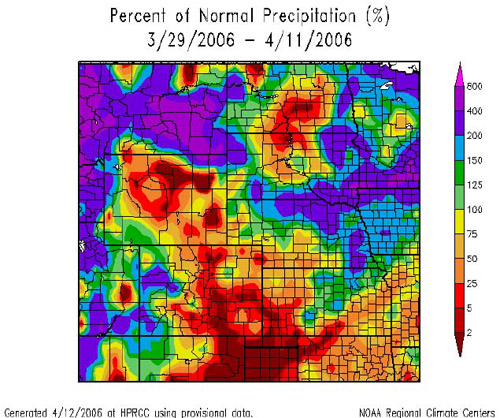
Figure 12. 2-Week Percent of Average Precipitation Ending April 11, 2006
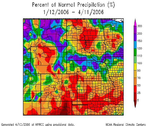
Figure 13. 90-Day Percent
of Average Precipitation Ending April 11, 2006
Departure from normal temperature for the last two weeks (Figure
14) and since January 1, 2006 (Figure
15), show temperature departures above average across much
of the Rocky Mountain Area, illustrated by the widespread orange and red
colors. The only exception to this is over the northern and central mountains
of Colorado and portions of southern and western Wyoming. These areas
have received above average snowfall, which has resulted in slightly cooler
than average temperatures.
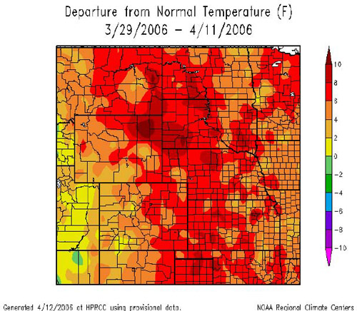
Figure 14. 2-Week Percent of Average [Temperature] Ending April 11, 2006
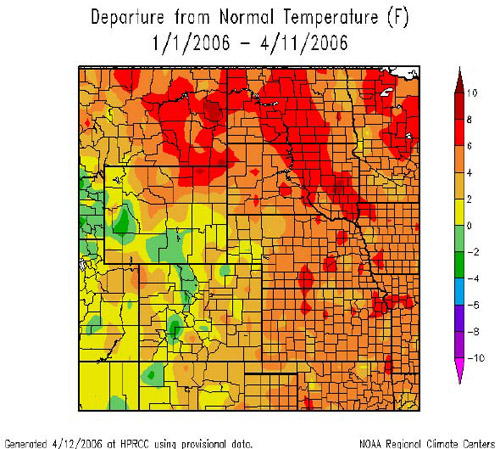
Figure 15. 90-Day Percent of Average [Temperature] Ending April 11, 2006
Current ENSO (El Nino Southern Oscillation-Figure
16) indices indicate weak La Nina (cold episode) conditions
in the Eastern Tropical Pacific. Weak to moderate La Nina conditions have
impacted weather patterns (resulting in warm and dry) across portions
of the southern and central Rocky Mountains during the past several months,
but to a lesser degree over the northern Rockies (Wyoming and Black Hills
region). Current NAO (North Atlantic Oscillations-Figure
17) anomalies are negative in the northern Atlantic. Negative
NAO anomalies may have impact on North American spring and summer climate;
including the Rocky Mountains (refer to the Climate and Weather Outlooks
Section).
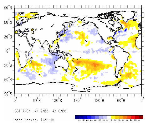
Figure 16. ENSO Sea Surface Temperature Anomalies for April 2-8, 2006
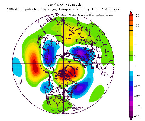
Figure 17. 500 mb Height Composite Anomaly from 1968-1996.
<<< continue
reading — 2006 Seasonal Outlook, Weather Outlooks For Spring and
Summer >>>
|
