
Accident Report
BATTLEMENT CREEK FIRE
Fatalities & Injury
July 17, 1976
- Location
- National
Fire Situation
- Fire
Environment
- Weather
- Topography
- Vegetation
and Fuels
- Origin
and Initial Suppression Effort
II. Fire Behavior and Burning Sequence on July 16 and 17, 1976
- General Situation
- Prior Weather
- Fire Behavior Appraisal
- Fire Behavior July 16
- Burning Sequence July 17
- Chaparral Model Nomograph
- Fire Behavior Summary
III. Suppression Effort and Accident Sequence
- Accident Sequence
- Post-Accident Rescue and Medical Action
IV. Investigation
V. Organization and Management
- Fire Overhead and Crew Assignments 7/16-7/17/76
- Overhead Qualification and Experience
- Crew Qualification and Experience
- Logistical Support
- Fire Planning and Intelligence
- Aviation Management Activity
- Mechanical Factors
- Physical Factors
- Human Factors
- Crew
- Overhead
- Management Factors
VII. APPENDIX
No Fire
Shelters in British Columbia, July 25, 2005 safety bulletin explaining
their change in policy, .pdf file, 2.2 mb
|
Accident
Report
BATTLEMENT CREEK FIRE
Fatalities & Injury
July 17, 1976
C. Fire Environment
1. Weather
The most basic meteorological conclusion that can be drawn from available
meteorological data and extensive interviews with personnel assigned on
the Battlement Creek fire, Saturday, July 17, is that the accident was
not directly weather related; i.e., there were no thunderstorms in the
" immediate fire vicinity between 1400 and 1500 m.d.t. that could
have produced downdrafts to affect the fire, no unusual or abnormal winds
occurred attributable to accepted meteorological causes such as fronts,
low level jet stream, or locally induced dust devils, etc.
At the time of the accident, the atmosphere was unstable, normal up-slope
winds were occurring, winds aloft were generally light SW and ranged from
5-15 m.p.h. from 6,600 feet to 31,000 feet m.s.l.
Observers on the fire at the time of the accident reported high winds
at ground level 25-35 m.p.h. and above.
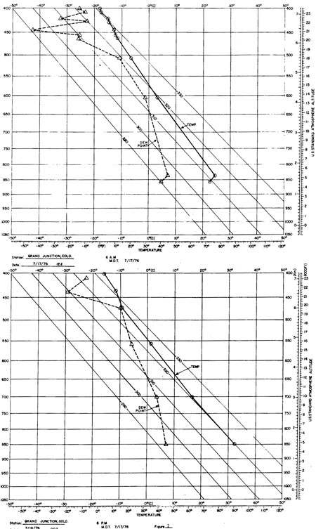
Figure 2. Morning and
afternoon soundings
Earlier in the day, the weather was described as fair, winds were light
both on the ridge and on lower portions of the fire. Some small whirl
activity was reported about 1230-1300 m.d.t. which would indicate unstable
atmospheric conditions. Figure 2 illustrates the morning and afternoon
soundings for Grand Junction, Colorado, on Saturday, July 17, 1976. They
illustrate typical summertime conditions of afternoon low-level heating
and instability. Generally observers reported high winds at the time of,
or just before, the accident. These were very likely local fire-induced
winds generated by very intense burning and rapid rate of spread.
A rather severe frost on June 14 (23-27°F. in the 6,200-9,000-foot
range) produced extensive damage to Gambel's oak stands in the fire area.
The frost was an important indirect weather-related event which increased
the dry fuel available for combustion by killing leaves in the oak stands.
Relatively warm, dry weather following the frost provided conditions conducive
to drying dead plant tissue.
2. Topography
Origin of the fire was 40 airline miles NE of Grand Junction, Colorado,
and 1-1/2 miles south of the Colorado River in the Battlement Creek drainage.
Battlement Creek is approximately 8 miles long and flows in a northwesterly
direction to the Colorado River. The fire burned entirely on the east
side of Battlement Creek (fig- 3). The topography varies from relatively
level land along the drainage bottom to rugged mountain slopes. Elevations
on the fire range from 6,200 feet near the origin to 8,400 feet near the
site where the men died. The fire burned primarily on north-facing aspects
on Thursday, July 15, and Friday morning, and on west-facing aspects on
Friday afternoon and Saturday. The slopes that burned on Saturday were
fully exposed to prevailing southwesterly air flow; and they received
direct solar heating from 1100 on. Slopes that burned on Saturday, July
17, ranged from 10 percent above the road to 75 percent in the chute just
below the ridgeline. The side drainage that burned out on Saturday was
characterized by two major draws, aligned in an east-west direction. The
head of the north draw was about 3,500 feet northeast of the Battlement
Creek road. This draw terminated just below a saddle on the ridgeline
where the Mormon Lake crew was working on Saturday. The south draw climbs
in an easterly direction for 3,200 feet from the road. Side slopes of
these draws were measured at 50-60 percent.
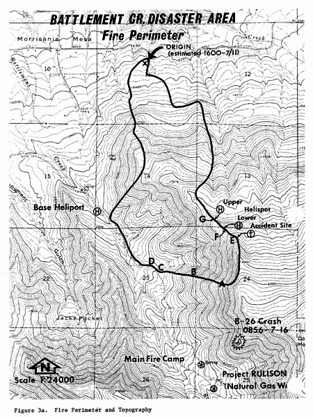
Figure 3a. Fire Perimeter
and Topography
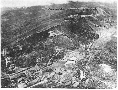
Figure 3b.--Oblique
aerial photograph of Battlement Creek
Fire area, July 19, 1976
Visibility to the west from the saddle above the north draw was restricted
due to the topography. The slope west of the ridgetop in the saddle was
gradual for about 140 feet and then broke off steeply (fig. 4).
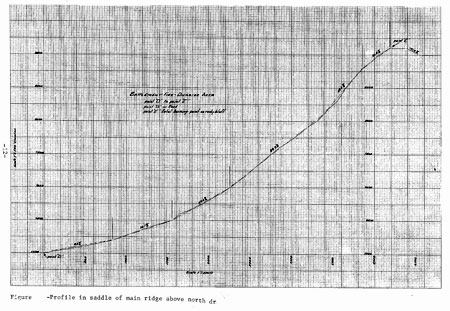
Figure 4. Profile in
saddle of main ridge above north draw.
(Notes from drawing: Lower left is point
'D' on road to upper right, point 'E' fatal burning point on rocky bluff.
Vertical scale (1"=100ft.) is different from horizontal scale (1"=200ft.).)
<<< continue
reading—Battlement Creek Fire, Vegetation and Fuels >>>
|