Esperanza FireAccident Review Board Action PlanCDF Green SheetAccident Investigation
|
Appendix 1 - Fire Behavior Analysis SummaryFire Behavior OverviewA wildland fire was reported along Esperanza Road in the town of Cabazon, California on Thursday, October 26, 2006 at approximately 1:11 a.m. Pacific Daylight Time (PDT). The fire was initially burning in light, flashy fuels and soon became established in steep, rocky terrain. It burned up hill, influenced by very steep slopes, to Cabazon Peak and spread to the west and southwest. Within the first few hours, the fire behavior exceeded direct attack capabilities of the first on-scene initial attack fire suppression resources. The fire was now estimated at approximately 500 acres. During this initial run, fire behavior was primarily influenced by steep slope, seasonally dry annual grass, and chaparral fuels. The developing Santa Ana Winds were still fairly weak with sustained winds out of the east at less than 10 mph. As the Santa Ana condition continued to develop, the winds maintained a steady speed at lower elevations while steadily increasing at the higher elevations. By 3:00 a.m. PDT, as the fire reached the upper elevations on the northern aspect of Cabazon Peak, wind speeds ranged from 6 mph gusting to 20 mph out of the east through Banning Pass while northeast winds were increasing in strength at the top of Cabazon Peak. These winds were now pushing the fire in a southwest direction toward the Hurley Flat area. Fire brands were carried to the west of Cabazon Peak and spot fires developed. Additionally, the fuel type transitioned from annual grasses and chaparral to heavier mixed mature chaparral intermixed with Manzanita, Mountain Mahogany, and Sage. Between 4:00 a.m. and 5:00 a.m. PDT, the wind speeds increased to 10 mph with gusts to 23 mph. Relative humidity was recorded at 6 percent. The fire made significant progress to the west towards the Hurley Flats and the Twin Pines Ranch area. Acreage was estimated between 900 to 1,500 acres. Extreme fire behavior with sustained head fire runs and spotting was observed. As the fire moved around the west side of Hurley Flat and into Twin Pines Creek, the terrain sheltered the wind which, essentially, slowed the progress of the fire. As the fire burned to the west of Twin Pines Creek drainage it began a significant up slope run as the fire came under the influence of the northeast Santa Ana wind. Spot fires were reported ½ mile ahead of the main fire front at this time. Between 5:30 a.m. through 6:30 a.m. PDT, the fire made a significant, sustained head run to the southwest that was influenced by channeling winds up Twin Pines Creek and its many tributaries. This run reached Twin Pines Road at a point about 1 mile directly south of the accident site. Relative humidity was holding between 5 percent and 6 percent and the north/north east winds had now increased to 13 mph, gusting to 31 mph. Public evacuations were implemented in the Twin Pines community, and residents in the Poppet Flat area were initially ordered to shelter in place, then evacuate as the fire threat passed and road conditions were declared safe. Additionally, engine personnel assigned to structure protection on Wonderview Road took defensive positions inside their engines as the fire front passed them. Fire size at this time was estimated around 2,200 acres. As the fire progressed to the south/southwest during the 5:30 a.m. to 6:30 a.m. run, it established on a ridge immediately east of the accident site. This fire was observed by engine personnel assigned to structure protection along Wonderview Road and Gorgonio View Road. Around 7:00 a.m. PDT, several factors came together to cause a rapid increase in northeast winds that directly influenced the fire behavior.
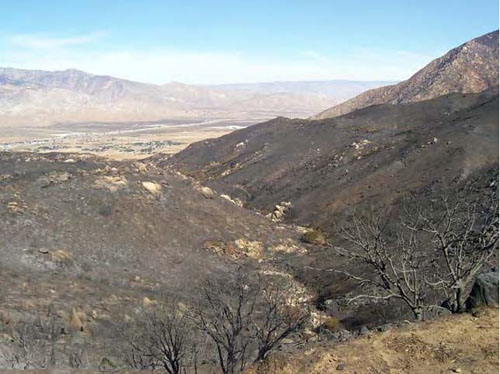
The fire reached the fatality site sometime between 7:00 a.m. and 7:30 a.m. PDT. The combination of strong surface wind speeds and the influence of the rising smoke plume, slopes, and heavy fuels along with significant spot fires burning together created an area ignition event. Firefighters assigned to structure protection on Gorgonio View Road and Wonderview Road observed the area ignition occur. They noted a topographical “bowl” about ¼ square mile in size became fully engulfed in flames in less than five minutes. The accident site was located at the top of the “unnamed creek drainage” on a round prominent knoll, with drainages on both sides that are tributaries of the “unnamed creek drainage”. The “unnamed creek drainage” is oriented northeast to southwest, in nearly exact alignment with the winds observed on the morning of October 26. The winds were channeled from the northeast directly up slope, up drainage to the accident site, which included the Octagon House. The weather factors came into alignment with the advancing fire front at a point in time to pull the fire front rapidly through the accident site. Firefighters located approximately 1,500 feet to the south of the accident site on Gorgonio View Road, estimated wind speeds between 50 and 70 mph in the local area. The wind direction and topographic shape of the accident site channeled the wind and flame directly at the Octagon House and Engine 57. As the flame front moved over and around the Octagon House, the shape of the house enabled the flame front to wrap around both sides of the house meeting on the downwind side. Fire HistoryThere is a notable history of wildfire occurrence in the geographical area of the Esperanza Fire documented in the California Interagency Historical Fire Perimeter Database. An analysis of records from 1950 through 2005 indicates that 11 fires have burned within the Esperanza Fire perimeter or vicinity during these 55 years. The presence of fire in the landscape is evidenced by existing fire scarred trees, and the current age classes of trees and shrubs. In the case of the Esperanza Fire, the age class of the shrubs and chaparral are consistent with the historical records from the database. This finding supports the commonality of fuel loading and fire frequency in the Esperanza Fire area. The age of the chaparral is representative of a fire return interval of 9 to 18 years. The following historical fires selected from the records confirm the established fire return interval.
Of historic note, three previous fatality fires occurred in the vicinity of the Esperanza Fire.
Fire EnvironmentFuels The predominant fuels represented in the area are common California Chaparral. Specifically, fuels were Manzanita, Mountain Mahogany, Sage, Chamise, and annual grasses. Fire Behavior Prediction System, (FBPS) fuel models 1 (grass) and 4 (Chaparral) were used to model surface fire behavior. Fire Resource Assessment Program (FRAP) categorizes the fire area as an extreme fire threat with a very high fuel rank. Fuels in the area historically average a growth density of 1 to 1.5 acre tons per year. The age class of fuel in the area was 17 years which is considered mature vegetation. The fuel loading is estimated to be 20 to 25 tons per acre. The average fuel height was five feet with areas of 8 foot intermix of Manzanita and Mountain Mahogany throughout. Overall, fuels were very volatile and had latent potential for significant energy release due to age and tons per area. Fuel moisture content was influenced by the normal summer season lows which occur between the months of September and December. Fuels had become increasingly dry and flammable. The old growth plants had developed fine to larger dead branches within which were kindling dry and able to promote rapid and large fire growth. Live fuel moistures were estimated at <60 percent in Chamise and Sage Brush. Manzanita and Mountain Mahogany which are larger broadleaf shrubs held a slightly higher value of <75 percent. The dead fuel moisture contents in the 1 and 10 hour timelag fuels were at an equal value of 3 percent at the time of the fire start. Based on on-site and predicted weather, the probability of ignition given these fuel moistures is between 80 percent and 100 percent. Fire consumption in 1, 10, and 100 hour fuels would achieve 100 percent and consumption in the live fuels would average 90 percent.
Fire Behavior Analysis Figure 2. Fuel loading after Esperanza Fire Weather A Red Flag Warning had been issued on Wednesday, October 25, 2006 at 10:34 a.m. PDT. The Red Flag Warning called for northeast winds 20 to 30 mph with gusts to 40 mph with relative humidity’s below 10 percent. At the Beaumont Remote Automatic Weather Station (RAWS) 9 miles west of the fire origination point, winds increased out of the east with gusts to 25 mph and relative humidity’s decreased below 10 percent shortly after 12:00 a.m. PDT on October 26. As reported by the Beaumont RAWS (the only reliable weather reporting site near the Esperanza Fire), winds continued to increase through the morning hours of October 26 with peak gusts reaching 39 mph at 10 a.m. Humidity remained at or below 10 percent during the entire day of October 26. Weather factors that significantly affected fire behavior on the morning of October 26 were:
When the Santa Ana Winds began shortly before 12:00 a.m. PDT on October 26, they brought very dry air with relative humidity at or below 10 percent through Banning Pass. The winds through Banning Pass along the valley floor remained out of the east through all of October 26. Once the Santa Ana Winds began, they increased in strength through the morning hours of October 26. While winds in Banning Pass were out of the east, winds over the terrain to the south, including the accident site, were primarily out of the northeast. These northeast winds were in alignment with the slope (blowing directly uphill) in some areas, and were blowing across the slope in other areas. Where the wind and slope were in alignment, fire behavior became extreme. This was observed by several firefighters who were located at different sections of the Esperanza Fire. The inversion played a critical role in holding the strong northeast winds near the ground. In the absence of the inversion, the northeast winds would have expanded upward with a net reduction in wind speed near the ground. With the inversion in place, the air movement was confined between the ground and the inversion. As the air moves southwest from the Banning Pass area across the steadily rising terrain, the space between the ground and the inversion decreases. The inversion also rises as the air moves over the higher terrain but at an amount less than the ground is rising. The result is there is less space for the air to move through, as the air moves southwest over the higher terrain. In this situation, the wind speed increases as the air rises over the terrain. Highest wind speeds occur along ridgelines that are perpendicular to the wind direction. The final factor that proved critical in how fast the fire front moved through the accident site was the inversion being penetrated by the smoke plume rising approximately 2 miles southwest of the accident site shortly before the burnover. As discussed in the weather section, this plume rose to between 18,000 feet and 24,000 feet at a location directly downwind of the accident site. When this plume penetrated the inversion, it acted as a relief valve on the resistance of the wind trying to blow between the inversion and the terrain. With the plume in place, air could rise upward into the plume as well as move downstream under the inversion. This allowed wind speeds to increase rapidly just as the fire front was moving up the “unnamed creek drainage” toward the accident site. The plume acted as a chimney draft pulling the air upward. The only place this air could come from was through the “unnamed creek drainage” past the accident site. Topography The topographic features throughout the area can be described as steep, very broken terrain with many branching drainages and narrow canyons. The accident site has a north to northeast aspect and the “unnamed creek drainage” below the accident site is aligned northeast to southwest. The “unnamed creek drainage” is 1.5 miles long and is approximately ¼ mile wide with average slope at 25 percent. The run of the slope is at average of 50 percent. These features will cause winds to channel, compress, increase in speed, and become erratic. The United States Geological Survey Map, USDA Forest Service, Cabazon Quadrangle California-Riverside County, 7.5- Minute Series and site visit was used to describe the topographic features of the accident site. FIRE BEHAVIORThe fire consumed an estimated 500 acres within the first 2 hours as it ran to the southwest up Cabazon Peak. Numerous spot fires, including one greater than ½ mile ahead of the fire front were reported by firefighters on scene. During the first five hours of the fire, flame lengths were 30 to 60 feet with head fire alignment and the rate of spread (ROS) was approximately 60 chains an hour (ch/hr). The fire’s westerly travel direction and rate of spread was influenced by the following variables:
The fire traveled in a southerly direction during the initial run due to topographic influences. When the fire reached the upper ridgelines, the easterly wind drove the fire in a westerly direction. Fire alignment created differences in spread rates depending if the fire was backing, flanking, or a running head fire. Several significant head fire runs developed prior to the burnover; two traveled ¼ mile in less than 3 minutes. The fire was realigning and intermittently traveling at 800 to 1200 Ch/hr or 10 to15 mph in full alignment. The intermittent fire runs would travel 40 to 120 chains or ½ to 1 ½ miles at a time. The fire was in full alignment with wind and slope at the time of the accident. Extreme fire behavior was encountered intermittently within the fire environment prior to the reaching the Octagon House and Engine 57. The fire drastically increased in velocity due to the converging of synoptic scale winds out of the northeast and terrain influences. These conditions aided and intensified the developing head fire run to the southwest to the ridgeline. As the fire increased in size, spotting became more prevalent with air and fuel temperatures rising from the influence of this dynamic. Multiple spot fires created area ignition as the fire established within the “unnamed creek drainage” came into slope and wind alignment. At the same time, a developing convection column was standing up within the strong wind field. The fire environment dominated the atmosphere with area ignition surrounding the accident site and a convection column rising between 18,000 feet and 24,000 feet. On-site accounts and scientific modeling confirmed a head fire run in excess of 30 miles an hour and winds exceeded 50 mph at the accident site. Burn indicators found in the trees at the accident site indicate the flame height remained within 15 feet of the ground. This is indicative of the wind remaining parallel with the ground and increasing in speed near the ground as the wind climbed the slope extending to the ridgeline. See Exhibits 2, 3, 4, 12, 13 for photos references of this section. 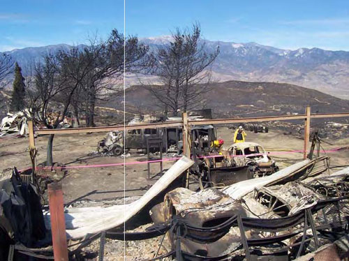 Fire Behavior Analysis Figure 3. Scorch Height
|
| © 2005-2021 Colorado Firecamp, Inc. | home • schedule • blog • ENGB • facility • about us• FAQ's |