 Esperanza FireAccident Review Board Action PlanCDF Green SheetAccident Investigation
|
GREEN SHEETCALIFORNIA DEPARTMENT OF FORESTRY AND FIRE PROTECTION
|
| Date | Time | Temperature | Relative Humidity | Wind Speed | Gusts | Direction |
| 10/26 | 0110 | 60 F | 5% | 8 | 21 | ENE |
| 10/26 | 0310 | 60 F | 6% | 8 | 20 | ENE |
| 10/26 | 0510 | 59 F | 6% | 10 | 23 | ENE |
| 10/26 | 0610 | 60 F | 7% | 13 | 26 | E |
| 10/26 | 0710 | 57 F | 8% | 13 | 31 | E |
| 10/26 | 0810 | 59 F | 10% | 15 | -ND- | E |
| 10/26 | 0910 | 62 F | 10% | 16 | 33 | E |
FIRE BEHAVIOR
Forecasted weather and the seasonally dry vegetation conditions categorized the fire with a high probability for large development. The fire produced a rapid rate of spread with extreme fire behavior conditions with wind dominancy. These conditions displayed increased spotting potential with flame lengths of up to 90 feet. A rate of spread of 20 mph was observed on level terrain. Wind and slope alignment produced a greater rate of spread to 40 mph which caused temperatures to exceed 1220 degrees Fahrenheit ahead of the fire front.
The fire was in full alignment with wind and slope at the time of the burn over. The fire drastically increased in velocity due to the converging of forecasted winds out of the northeast and terrain effects. The fire environment dominated the atmosphere with area ignition conditions surrounding the fatality site. A convection column of up to 18,000 feet high occurred.
LOCATION OF BURN OVER
(See attached detail map for visual representation)
On Thursday October 26, 2006, at approximately 0111 HRS a fire was intentionally set on Esperanza Road at the bottom of a slope near the town of Cabazon, California in State Responsibility Area (SRA). It quickly spread southwest uphill toward State Highway 243 and the rural residential community of Twin Pines.
Initial attack fire apparatus were dispatched from the California Department of Forestry and Fire Protection (CDF). At approximately 0123 HRS CDF/Riverside County Fire Medic Engine 24 arrives at the scene. Engine 24 assumes Esperanza Incident Command (IC) and reports that the fire is approximately 10 acres with a rapid rate of spread and is well established on the hillside. The IC advises the Perris Emergency Command Center (ECC) that the fire might have entered the United States Forest Service (USFS) direct fire protection area. At 0130 HRS, Perris IC requests five Type III Engines from the USFS. At approximately 0132 HRS, the first arriving CDF Battalion Chief arrives and assumes command. At approximately 0307 HRS, Esperanza IC is transferred to a CDF Division Chief. The IC reports that the fire is 500 acres plus and has reached the top of Cabazon Peak.
Between 0330 - 0402 HRS, BDF Engines 51, 54, 56, 52 and 57 assemble at the Incident Command Post. The engines are instructed to respond to the Twin Pines area for structure protection. At approximately 0515 HRS, BDF Engines 52 and 57 arrived at Hwy 243 and Twin Pines Road and assigned to Branch II (Position held by a CDF Battalion Chief). They were given the assignment of evacuations and structure protection in the Gorgonio View Road and Wonderview Road area. BDF E57 and E52 access Wonderview Road directly from Twin Pines Road. At approximately 0550 HRS, BDF E52 arrived at a residential structure and identified an elderly woman that needed to be evacuated and are committed. BDF Engine 57 drove down Wonderview Road and turned right on Venison Road. BDF E57 stopped at 49550 Venison to check on a residential structure under construction, referred to as the “Tile Roof House”. The home was found to be empty. BDF E57 left the “Tile Roof House” and drove back to Wonderview Road until reaching the “T” intersection of Wonderview Road and Gorgonio View Road. BDF E57 then turns right and arrives at 15400 Gorgonio View Road. As the branch director drives south on Gorgonio View from Wonderview Road, he makes contact with BDF Engines 51, 54, 56 and March Brush 10 at a mobile home referred to as the “Double Wide”.
At approximately 0620 HRS, the Branch Director meets with BDF E57 at 15400 Gorgonio View Road and discusses their plan, state of the weather, topographical features, locations of other resources, and safety zone.
At an unknown point in time after the Branch Director left 15400 Gorgonio View Road, BDF E57’s crew deploys firefighting equipment. They deploy a portable pump at the swimming pool located to the west of the main residential structure and attach a 1 ½” hoseline which is laid out to the east side of the residence. A 1 ½” hoseline was attached to a rear discharge of BDF E57.
At approximately 0640 HRS, the Branch Director contacts the Operations Section Chief (Position held by a CDF Battalion Chief) and the Twin Pines Structure Group leader to advise them of extreme fire spread upslope toward Twin Pines Ranch Road. He advises them to start evacuations at Poppet Flats.
At approximately 0700 HRS, the fire burns up the Twin Pines Drainage and crosses HWY 243 south of Twin Pines Ranch Road and is described by the Branch Director as having very extreme fire behavior with multiple spot fires. At approximately 0710 HRS, the fire also established within the “unnamed” drainage below 15400 Gorgonio View Road. Slope and wind alignment in conjunction with multiple spot fires which resulted in an area ignition event. These conditions developed a headfire run to the Northwest and to the ridgeline. The winds exceeded 50 mph during this event.
The speed and intensity of this fire run overwhelmed the crew of BDF E57. At approximately 0745 HRS, a search for the crew of BDF E57 began. At approximately 0800 HRS, emergency medical treatment was rendered to the survivors.
Three firefighters perished at the scene. One firefighter died en-route to the hospital and the fifth died on 10/31/06 from the injuries.
A 2001 USDA Forest Service Fire Engine Type III Model 62 was completely destroyed by the passing fire front.
~ ### ~
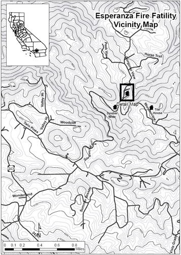
Esperanza Fire Fatality Vicinity Map
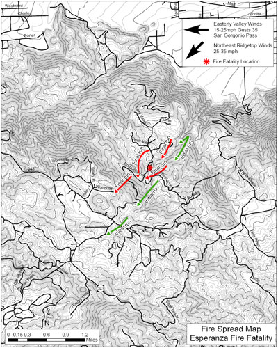
Esperanza Fire Fatality, Fire Spread Map
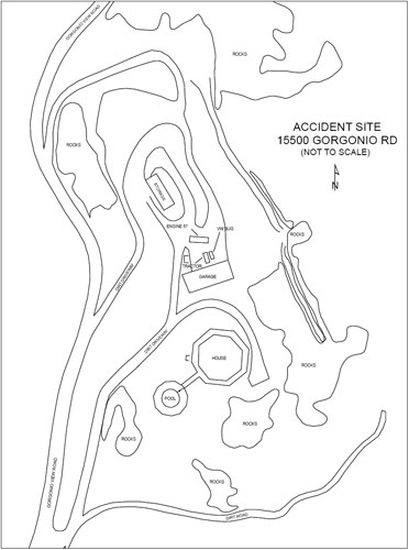
Accident Site, 15500 Gorgonio Rd.
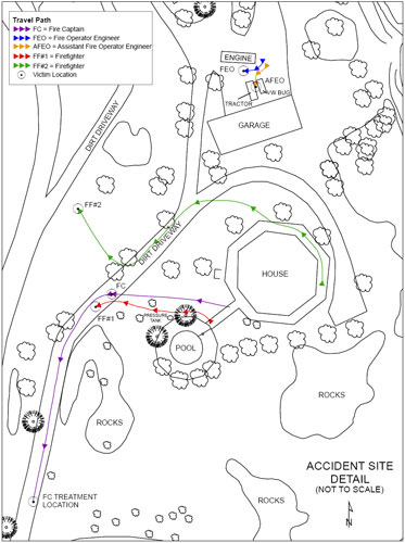
Accident Site Detail
| © 2005-2021 Colorado Firecamp, Inc. | home • schedule • blog • ENGB • facility • about us• FAQ's |