Esperanza FireAccident Review Board Action PlanCDF Green SheetAccident Investigation
|
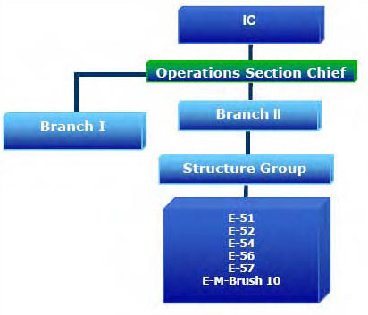
NarrativeThe Esperanza Fire started in Cabazon, California in Riverside County. Cabazon is located on the valley floor on the northern side of the San Jacinto Mountains. The mountains rise dramatically in elevation from the desert floor at 1,700 feet to 4,000 feet in elevation to the rural mountain community of Twin Pines approximately four miles to the southwest. Twins Pines is a wildland urban intermix of dispersed residences on private land nestled at the head of a canyon. Lower portions of Twin Pines are accessible by narrow, winding, unpaved roads. The Twin Pines area is surrounded by the San Bernardino National Forest to the east and south. (See Figure 9, page 15, USFS and CAL FIRE Direct Protection Area Map) The Twin Pines community is identified in the Mountain Area Safety Taskforce (MAST) Report as a very high to extreme threat area for potential destructive impacts from wildland fire due to physical orientation, surrounding dense chaparral/Manzanita, exposure to upslope winds, and alignment with potential Santa Ana winds. (See Figure 12, Page 18, Fire Threat and Fuel Rank Map for the Twin Pines area.) The Esperanza Fire was first reported on Thursday, October 26, 2006, at 1:11 a.m. Pacific Daylight Time (PDT) burning at the base of the hill in the town of Cabazon. A red flag warning had been identified and was in effect. The probability for large fire growth was likely if the fire escaped initial attack given forecast conditions for high temperatures, low humidity, and Santa Ana winds. Initial attack resources were promptly dispatched from the California Department of Forestry and Fire Protection (CAL FIRE) and the first fire engine, RVC Medic Engine 24, arrived on scene at 1:18 a.m. Initially, the fire was approximately two acres in size and located on the base of the hillside. At 1:24 a.m., the first arriving Battalion Chief (BC) from CAL FIRE reported the fire had grown to approximately ten acres with a rapid rate of spread, and had crossed the road east of the main drainage at a location called “Hallis Grade”. (See Figure 8, Page 14, Esperanza Fire Progression Map) The BC concluded if the fire advanced into the drainage this would be a trigger point for the evacuation of residences in Twin Pines. The BC contacted the Perris Emergency Command Center (ECC) and advised personnel that the fire may have entered a designated Forest Service Direct Fire Protection Area (DPA) and requested the pre-planned response of five single resource Type III fire engines from the San Bernardino National Forest (BDF). At approximately 1:32 a.m., the Battalion Chief assumed the role of Incident Commander (IC) and informed ECC that this fire was a “major, wind-driven [fire], with an uncontrolled perimeter due to fire behavior and fire intensity.” He estimated the fire could potentially grow in excess of 25,000 acres and characterized the fire behavior as abnormal compared to his experience with previous fires in the same general location. Several fires had occurred in previous months; these fires had typically burned from east to west, skirting along the north aspect of the mountain. This fire was different because it was influenced by a northeast wind, was burning uphill, and advancing into steeper drainages. At 1: 43 a.m., BDF dispatch requests Forest Service Fire Engines 51, 52, 54, 56, and 57 respond to the fire. At 1:53 a.m., the Esperanza Incident Commander directed more suppression resources into the Twin Pines area due to the perception of the growing fire heading towards the community. He also anticipated the need for air support and requested eight Type II helicopters, two Type 1 helicopters, and six air tankers to be available at sunrise. At 3:07 a.m., the Esperanza Incident Commander duties were transferred to a CAL FIRE Division Chief. By this time, the fire was approximately 500 acres and had progressed up and over nearby Cabazon Peak (4,520 foot elevation). Between 3:30 a.m. and 4:02 a.m., Forest Service Fire Engines 51, 52, 54, 56, and 57 responded from the San Jacinto Ranger District and reported to the Incident Command Post (ICP) located in Cabazon. At 4:02 a.m., when they arrived at the ICP, instructions were given to travel to the Twin Pines area to assist with structure protection. At 4:00 a.m., the evacuation of Twin Pines was ordered by the Esperanza Incident Commander. All five engines left the ICP heading towards a staging area at the junction of Twin Pines Road and Highway 243 at 4:18 a.m. While en route, Engine 51 reported a new fire start alongside Interstate 10 and was diverted to suppress this fire. The other four engines continued traveling towards the staging area. (See Figure 5, Page 11 – Branch II Map) The four engines encountered people fleeing in vehicles down the highway which added to the emerging chaotic conditions. Engine personnel reported the road was obstructed with numerous civilian vehicles, motor homes, horses, and livestock. Due to the traffic congestion, the four fire engines became separated therefore Engines 52 and 57 arrived at the staging area first. Supervisors working in the Twin Pines area were CAL FIRE personnel, who included an Operations Section Chief, Branch Director II (Branch II), and a Structure Protection Group Supervisor. Fire Engine 52 and 57 Captains met with the CAL FIRE Battalion Chief who had assumed the duties of the Branch II Director (Branch II). He instructed the engine captains to drive down the unpaved Wonderview and Gorgonio View Roads into the lower Twin Pines basin area to triage houses and “see what they could do.”
At approximately 4:50 a.m., Engines 54 and 56 arrived at the staging area; however, due to the roadway being blocked by civilian vehicles, they were forced to drive further down the road. Engine 56 Captain walked back to meet with the CAL FIRE Battalion Chief who was designated as the Twin Pines Structure Protection Group Supervisor and he gave Engine 56 Captain an assignment to “go down Wonderview Road and perform structure triage.” Engine 56 Captain then returned to his engine and met with Engine 54 Captain to relay the instructions. Engine 54 and 56 Captains then met with Engine 52 and 57 Captains to talk about the mission. Between 5:15 a.m. and 5:30 a.m., Engines 52 and 57 traveled down Wonderview Road. Engines 54 and 56 were instructed by the Twin Pines Structure Protection Group Supervisor to wait along Twin Pines Road to meet with an incoming March Air Force Base – Brush 10 Fire Engine (MB-10). At 5:30 a.m. Engine 52 stopped at 16600 Wonderview Road and found a resident who did not want to leave their home. Engine 57 continued alone traveling down the road approximately ¼ of a mile and stopped at a house under construction at the junction of 49550 Venison Road (Tile House). Engine 57 Captain sized-up the Tile House and the rest of Venison Road then turned around and continued traveling down Wonderview Road. He then radioed Engine 52 Captain and advised that the Tile House had “room enough for two engines,” and that he would continue on down and look for other buildings. Engines 52 and 57 maintained ongoing communications using a Forest Service tactical radio frequency not assigned to the fire during this time. While Engine 57 was triaging houses along Wonderview Road, Branch II met up with Engine 52. Engine 52 Captain told Branch II they could not convince the resident to leave. At 5:44 a.m., Branch II requested law enforcement assistance with the evacuation. Branch II then left this location, after instructing Engine 52 Captain to remain there until the resident had been evacuated. At approximately 6:00 a.m., Branch II reported a dramatic increase in fire activity. The fire had reached the upper end of Hallis Grade and was progressing farther up the drainage. He noticed the fire was mostly a slope/fuel driven run and estimated the fire had spread approximately ½ to ¾ of a mile in 15 minutes. He radioed the Operations Section Chief and advised him that the fire had crossed Wonderview Road and was moving rapidly towards Twin Pines Road. Branch II then continued down Wonderview Road checking on conditions. Between 5:45 a.m. and 6:00 a.m., Engine 52 completed the evacuation and continued traveling down Wonderview Road to set up position at the Tile House, 49550 Venison Road. Engine 52 Captain contacted Engine 57 Captain to tell him that they were set up and concurred there was room for two engines. Engine 57 Captain responded that he was at a “good location,” there was a pool for a water supply and he intended to remain at this location, which was 15400 Gorgonio View Road (Octagon House, See Figure 5, Page 11). Engine 51 was released from the second fire along Interstate 10 and arrived at the staging area at approximately 5:45 a.m. He was instructed by the Twin Pines Structure Protection Group Supervisor to join Engines 54, 56, and MB-10 to perform structure triage along Wonderview Road. Engines 54, 56, and MB-10 attempted to drive down Wonderview Road but found that it was inaccessible because the fire had crossed the road. During this same time frame, the main fire reached the area of Engine 52 at the Tile House. Engine 52 personnel took defensive actions and retreated to the fire engine during the peak of fire activity. At 5:53 a.m., Engines 54, 56, and MB-10 drove back to Twin Pines Road where they meet up with Engine 51. They were then assigned to drive down Gorgonio View Road to continue structure protection and arrived at a doublewide mobile home (Doublewide). While traveling along Gorgonio View Road, Engine 51, 54, and 56 Captains communicated using a Forest Service tactical radio frequency not assigned to the fire about concerns regarding the exit behind them being cut off by the fire, and the fact they were driving down “into a bowl.” The roadway was described as being narrow and surrounded by a lot of vegetation. They encountered a person in a motor home fleeing the area driving in an erratic manner. At approximately 6:20 a.m., Engines 51, 54, 56 and MB-10 met Branch II along Gorgonio View Road and were directed to stay at 15975 Gorgonio View Road (Doublewide) where they now began to quickly size-up the structure and make defensive plans. (See Figure 6, Page 12 – Fire engine locations at the Esperanza Fire Accident Site Map) At this time, Branch II noticed lights at a location approximately ¼ mile below the Doublewide, so he drove down the road and found Engine 57 parked at the Octagon House, which was built on a flat promontory. Branch II contacted firefighters standing next to the engine and instructed them to put on their line packs, including personnel protective equipment (PPE). He then had a conversation with Engine 57 Captain about PPE, the fire environment, and a lookout opportunity at this location. Not far from the engine, they stood at the edge of the property where they could see the “unnamed creek drainage”[1] that dropped sharply off below them. The fire was still up on the ridge to the east and progressing south toward Twin Pines Road. Branch II finished his meeting with Engine 57 Captain at approximately 6:30 a.m. and drove back up Gorgonio View Road, briefly stopping at the Doublewide to inform Engine 51 Captain of Engine 57’s location before driving back to Twin Pines. At approximately 6:40 a.m., Branch II contacted the Operations Section Chief and Twin Pines Structure Protection Group Supervisor and advised them of the extreme fire activity heading upslope toward Twin Pines Road, and he recommended the evacuation of the Poppet Flats area, south of Twin Pines. At 6:45 a.m., he met with Twin Pines Structure Protection Group Supervisor and they agreed on their overall triage and structural triage plan of action along Twin Pines Road and down Gorgonio View and Wonderview Roads. Sometime between 6:30 a.m. when Branch II left the area, and 7:15 a.m., Engine 57 set up a portable pump in the swimming pool at the Octagon House. Connected to the pump was a 100 foot section of 1½ inch hose extending to the east side of the residence with a 1½ inch nozzle attached. The pump was later found in the running position at full throttle. There was also a 1½ inch hose attached to the rear discharge of the engine without a nozzle. Meanwhile, firefighters at the Doublewide continued to deploy hose and prepared the area for a burnout operation, which needed to be accomplished before the advancing fire front reached their location. All five Forest Service Engine Captains continued to maintain frequent communications with each other using a Forest Service tactical radio frequency not assigned to the fire and not monitored by Esperanza Incident Command staff. Between approximately 6:45 and 6:50 a.m., Engine 52 Captain informed Engine 56 Captain that the fire is “boiling up at the bottom down below.” Then Engine 57 Captain contacted Engine 51 Captain and advised to “begin firing now.” After unsuccessful attempts using assigned fire radio frequencies to contact Branch II to inform him of the burnout operations, the burnout was performed by Engines 51, 54, 56, and MB-10 around the Doublewide. Following notable holding/suppression actions, all firefighters at the Doublewide took refuge in the fire engines during the peak of ember showers, smoke, and the passage of the main fire front at approximately 7:15 a.m. Attempts by Engine 52 to contact Engine 57 went unanswered at approximately 7:15 a.m. At approximately 7:57 a.m., the heat and smoke had diminished enough for Engine 51 and 52 Captains to work their way into Engine 57’s location to discover the burnover. Immediate attempts by Engine 52 Captain to make an emergency call for assistance on the assigned fire command channel were unsuccessful, so he switched over to a Forest Service radio frequency and made contact with the Federal Interagency Communications Center (FICC). Following some initial confusion at the ICP over what was happening and where, the first agency medevac mission was activated with United States Forest Service Helicopter 535. Due to its Type III status and high winds, Helicopter 535 was unable to meet the mission. CAL FIRE Helicopter 301, a Type II, was able to land near the accident site at 8:22 a.m. to transport one burn victim. A second Type II helicopter, CAL FIRE Helicopter 305, then transported the second burn victim at 8:35 a.m. The bodies of the three deceased firefighters were removed from the site at approximately 7:09 p.m. PDT. (See Figure 7, Page 13, Fire Engine 57 personnel travel paths) The Esperanza Fire quickly transitioned to a Type I Incident Management Team. During the first operational period, many residents were safely evacuated. After several days, the Esperanza Fire ultimately consumed approximately 41,173 acres and destroyed 34 residences and 20 outbuildings. The fire also forced the closure of Highway 243. < < < continue reading—Esperanza Fire Factual Report, maps > > >
|
| © 2005-2021 Colorado Firecamp, Inc. | home • schedule • blog • ENGB • facility • about us• FAQ's |