2006 RMA Preliminary Seasonal Fire Weather/Fire Danger Outlook
— April 13, 2006
|
Rocky Mountain Area Predictive
Services
2006 Preliminary Seasonal Fire Weather / Fire Danger
Outlook
April 13, 2006
Tim Mathewson
RMA Fire Meteorologist
Russ Mann
RMA Fire Meteorologist
Randal Benson
State of South Dakota Meteorologist
Marco Perea
RMA Intelligence
Rocky Mountain Area (RMA) Predictive Services
provides fire weather and intelligence support to the 10 cooperating
agencies of the RMA, which are the USDI Bureau of Indian Affairs, the
USDI Bureau of Land Management, the USDI Fish and Wildlife Service,
the USDI National Park Service, the USDA Forest Service, and the states
of Colorado, Kansas, Nebraska, South Dakota and Wyoming.
This document is also available in Adobe
pdf format, 5.6 mb.
A. Executive Summary
Current and expected weather trends and fuel conditions have resulted
in an Above Average Fire Potential forecast for an area
that extends from southwest-southern-eastern Colorado, northward to near
the Black Hills and Big Horn region for the 2006 fire season. This area
of above average fire potential also extends into western Kansas and western
Nebraska, however green-up and increasing dew points over the plains should
diminish fire concerns for that area by late April. Because of precipitation
deficits over the last several months, portions of southern Colorado will
continue to experience earlier than average fire potential. Average fire
potential is expected for much of western Colorado and much of western
Wyoming, but will need to be watched closely during the spring, as climate
predictor impacts become clearer. Above average snowpack should reduce
the risk of large fire activity in 2006 over the northern and central
mountains of Colorado. This outlook will be updated by June 1,
2006.
Contributing Factors and Considerations to the Outlook:
-
“Abnormally Dry” to “Moderate” drought conditions
were noted across much of the Rocky Mountain Area. Drought conditions
have significantly improved across Wyoming and the Black Hills during
the last year, but have worsened across Kansas and eastern Colorado.
-
Above average snowpack was noted over the northern and central mountains
of Colorado and western mountains of Wyoming. Below average snowpack
was noted across the Black Hills, and the Front Range of Colorado
(especially southern). Portions of the lower foothill regions of the
Colorado Front Range and adjacent plains of eastern Colorado and Kansas
had significant precipitation deficits. Despite some recent improvement,
snowpack over the southern and eastern San Juan Mountains was below
average.
-
“Weak” to “Moderate” La Nina conditions were
declared in the eastern tropical pacific by late fall/early winter.
The fall/winter precipitation patterns of 2005/2006 in the Rocky Mountain
Area were similar to past La Nina events. El Nino Southern Oscillation
(ENSO) forecasted indices suggest weakening of La Nina conditions
through the end of 2006. La Nina conditions could have impacts on
temperature and precipitation patterns across the U.S. through the
Spring and possibly Summer of 2006 before returning back to neutral
conditions.
-
The North Atlantic Oscillation (NAO) (defined by the difference between
high pressure from the eastern sea board into south-central Europe
versus low pressure over Iceland) was negative during the winter months
of 2006. Composite anomalies of spring and summer temperature, RH,
and precipitation rates during past negative NAO events paint a very
bleak (hot and dry) picture for portions of Rocky Mountain Area this
spring and summer, especially over Colorado, Wyoming and the Black
Hills.
-
2006 Spring (April thru June) Climate Prediction Center (CPC) outlooks
point towards drier than average conditions across the eastern two-thirds
of Colorado and much of Kansas, with near the climatological averages
elsewhere. Similar conditions are forecast for the summer period (June
thru August). The temperature outlook for spring and summer suggests
above average readings across southern sections of the RMA. Near average
precipitation is expected across Wyoming and the Black Hills through
June, with dry conditions setting up July and August for that area,
especially east of the divide.
-
Predictions also suggest an early onset of the Southwest Monsoon,
based on winter precipitation and snowpack correlations in the Southwest.
A late start in 2005 resulted in hot and dry conditions (above average
fire potential) across portions of the Rocky Mountain Area in July,
with some relief in August. Though outlooks suggest an early
onset of the Southwest Monsoon, position and northern extent of the
monsoon moisture is the biggest wildcard for the RMA.
-
Windier than average conditions are expected to continue through
the spring, especially east of the divide. Wind driven grass fire
activity will likely continue across the plains east of the Divide,
before green-up and higher humidity diminish the threat.
-
Early April Energy Release Component-G (ERC-G) curves show above
average readings across southern and eastern Colorado, and near average
readings elsewhere (ERC is an index used to determine fire potential,
among others).
-
As a result of a wet spring in 2005, abundance of carryover fine
fuels exists across the RMA. Over 100,000 acres has burned in the
Rocky Mountain Area since January 1, 2006, with over 90,000 acres
burned in Colorado and Kansas alone. Most of these acres burned in
fine fuels.
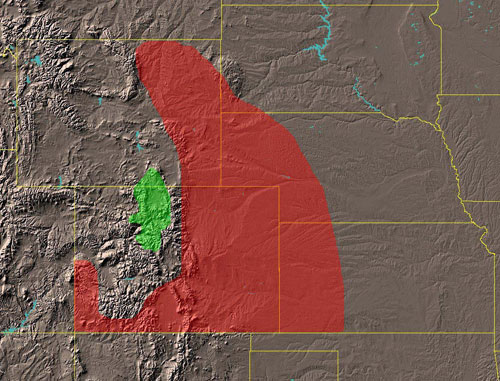
Figure 1. RMA Fire Potential for 2006 Wildland Fire Season (Red-Above
Average, Green-Below Average, No Color-Average)
<<< continue
reading — 2006 Seasonal Outlook, Current Conditions and Comparisons
with Historical Records >>>
|
