Point Fire, 1995
&
Island Fork Fire, 1999
dedication
Point Fire Case Study
Point Fire Accident Investigation
A. Point Fire Overview
B. Investigation
C. Recommendations
D. Supporting Data
- Sequence of Events
- Organization Charts
- Site Investigation
- Fire Behavior Report
- Property Damage Report
- Witness Statements
- Outline of Kuna Wildland Training Provided by BLM
E. Records and Reports
- Preplanned Dispatch
- BLM Radio Transmission Log
- Ada County Dispatch Log
- Fire Incident Status Summary
- Escaped Fire Situation Analysis
- Wildland Fire Entrapment Report
- Technical Analysis of Personal Protective Equipment
- Vehicle Inspection
- Weather Reports
F. Glossary
——————
Island Fork Fire Accident Investigation
——————
Point Fire — U.S. District Court Civil Case
Ruling on I.C.'s Decisions - Nov. 10, 1998
• Factual Background
• Legal Analysis
Ruling on BLM Liability - Feb. 19, 1999
• Findings
of Fact
• Legal Standards
• Analysis
Ruling on Public Safety Officer Benefits
(PSOB)
——————
——————
Colorado Firecamp extends special thanks to Linda Perkins, BLM
Idaho State FOIA Coordinator, for her friendly assistance in gathering
the Point Fire documents. BLM FOIA Letter
|
POINT
FIRE
ACCIDENT INVESTIGATION
Point Fire Overview (continued)
Date of Incident: July 28, 1995
Time of Incident: 1829 MDT
Incident Name: Point Fire
Legal Description of Location: T1N R1W Section 35 SE1/4 NW
Red Flag Warning
At 2022, BLM Boise Dispatch reported a “red flag warning”
for dry lightning and locally strong winds had been issued by the National
Weather Service. Red flag warnings are given to alert fire personnel to
potentially dangerous conditions. At the Point Fire, wind gusts of up
to 50 miles per hour were predicted from a thunderstorm, or “cell,”
that was moving northward at about 30 miles per hour. [————]
radioed [————] and requested that he reinforce
the fire’s northern perimeter. Upon receiving the red flag warning,
[————] alerted Engines 61, 67 and 83 along the
northern perimeter to anticipate gusty winds.

Winds were mild with
flame length in the 3 to 5 foot range. A little more than an hour after
crews arrived, the fire spread had been stopped.
Kuna RFD Engines 620 and 622 continued to mop-up along the perimeter
working west along the northern flank, then south around the west end
and turning east. They passed the BLM dozer, Engines 425 and 09, ending
up at a fence on the southeast corner of the fire line. There, Kuna RFD
Engine 622’s crew met with [————] [————]
driving the Wild West slip-on. Kuna RFD Engine 622 received directions
over [————] radio to turn around and work back
around the perimeter, and to soak the perimeter with water. Kuna RFD Engines
622 and 620 (in that order), turned around and worked their way west along
the southern perimeter. The Kuna engines worked in tandem to the southwest
corner, then turned north and worked along the west perimeter, where Kuna
RFD 622 ran out of water. Kuna RFD Engine 620 the went around Engine 622,
using its remaining water. While following along behind Kuna RFD Engine
620, Engine 622 contacted the BLM IC for instructions. [————]
informed Kuna RFD Engine 622 to refill with water and standby due to predicted
high winds. At that time Kuna RFD Engine 622 pulled off the line and drove
east through the burned area toward Swan Falls Road.
Kuna RFD Engine 622, just prior to reaching Swan Falls Road, was contacted
by Kuna RFD Engine 620 on the radio (BLM tactical channel [—]).
Engine 620’s crew said that the vehicle was overheating. Kuna RFD
622 instructed the crew to remove the screen from the radiator. Kuna RFD
Engine 620 acknowledged, “Remove the screen.” After a time,
Kuna RFD 622 pulled onto Swan Falls Road, turned south, and met with Tender
625, located south of the southeast corner of the fire, where refill operations
started. Kuna RFD Engine 620 was not with Engine 622.
Sometime after Kuna RFD Engine 622 went to refill, Kuna RFD Engine 620
passed Engine 61 and 67 on the west end of the fire line. Soon after,
and for unknown reasons, Kuna RFD Engine 620 turned north on a two track
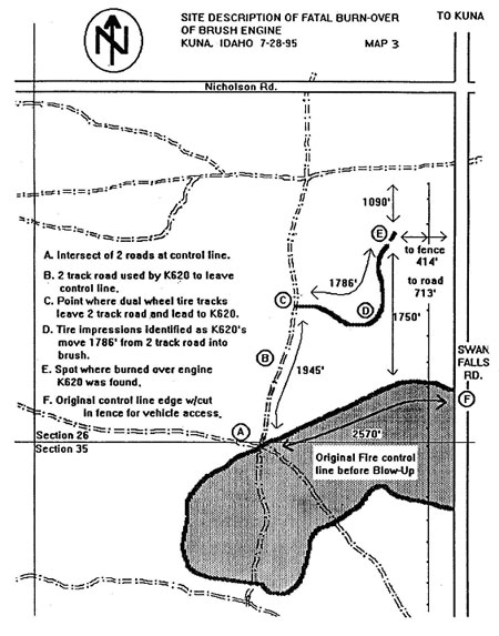
road at its intersection along the northern perimeter. (See Map #3, point
A.) Kuna RFD Engine 620 traveled along the two-track road for 1,945 feet
(point C), where it turned off the two tracks and drove east and then
north-northeast cross country another 1,786 feet through heavy sagebrush.
At this point, the vehicle became disabled (point E). The vehicle was
713 feet west of Swan Falls Road and 1,750 feet north of the northern
fire perimeter.

Map #3
At about 2046, the fire escaped from the northern perimeter at several
locations, fanned by strong southerly winds from the thunderstorm. [————]
[————] and [————] [————],
a BLM fire investigator, were in a Suburban and immediately drove north
on Swan Falls Road, about 2,000 feet from the original northern perimeter
to assess fire behavior. To their surprise and horror, they witnessed
a stationary Kuna engine in the path of the oncoming flame front. [————]
repeatedly attempted to radio the Kuna Engine and Kuna Command on the
BLM tactical channel, but received no response. [————]
then radioed Engine 83’s foreman, [————]
[————], a trained medical responder, and advised
him that his skills may be needed. [————] also
radioed Boise BLM dispatch and requested an ambulance and police assistance.
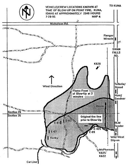
(See Map #4.) At that time, [————] was unsure
if Kuna RFD Engine 620 was occupied.

Map #4
At 2049, Kuna RFD Engine 620 contacted Kuna Command on the Ada County
South frequency and reported, “We’re on the north line, [————],
we got fire coming hard and this thing has died.” The speaker was
[————] [————], a [————]
volunteer fireman with Kuna RFD. The second fireman in the vehicle was
[————] [————], of the
Kuna RFD. A minute later, Engine 620 contacted Kuna Command again on the
same channel. “It’s not going to let us out of here!”
Kuna 650 asked Engine 620, “What kind of problem to you have?”
[————]’s reply was, “We’re surrounded
by fire!” Kuna 650 asked him to repeat. “The truck’s
been overtaken by fire!”
That was the last transmission from Kuna RFD Engine 620.
The fire was moving rapidly and burning intensely. Flame lengths were
at least 20 feet long, and the rate of spread was estimated to be about
560 feet per minute. It took 4 minutes from the point of escape for the
fire to overrun the truck. (See Map #5.)
<<< continue
reading—Point Fire Investigation, Rescue Attempts >>>
|