
 South
Canyon Fire South
Canyon Fire
1994
6 Minutes for Safety — 2009
Fire Behavior Report, 1998
Fire Environment
- July 2 to
Evening of July 5
- July
5, 2230 to July 6, 1530
- July 6, 1530
to 1600
- July 6, 1600
to 1603
- July
6, 1603 to 1609
- July 6, 1609
to 1610
- July 6, 1610
to 1611
- July 6, 1611
to 1614
- July 6, 1614
to 1623
- July
6, 1622 to 1830
- July
6, 1830 to July 11
References
Appendix A
Appendix B
Appendix C
|
 Fire
Behavior Associated with the 1994 South Canyon Fire on Storm King Mountain,
Colorado Fire
Behavior Associated with the 1994 South Canyon Fire on Storm King Mountain,
Colorado
Fire Chronology (continued)
July 2 to Evening of July 5—Low Intensity Downslope Spread
Lightning ignited the South Canyon Fire on the afternoon of July 2, 1994,
near the southernmost point on the Main Ridge. The fire was reported to
the county sheriff at 1030 and to the BLM district office at 1100 on July
3, 1994. The fire burned primarily in the open pinyon-juniper fuel type,
backing downslope in cured annual and perennial grasses with occasional
upslope runs and torching. It grew to 11 acres by the evening of July
4 (fig. 19).
The fire burned through the night of July 4, growing to 29 acres by 0800
on July 5. It continued to spread down the slope in the surface fuels
beneath the pinyon-juniper and Gambel oak through the day on July 5. The
direction of spread was mostly to the north and west. Burning was not
continuous and many unburned islands of fuel remained.
On July 5 seven BLM firefighters, including Incident Commander Blanco,
walked into the fire from the East Drainage. They cut a helispot (H-1)
and began direct downhill fireline construction. About 1500 an airtanker
made a retardant drop on the fire burning on the steep rocky slope above
the interstate highway. The BLM firefighters left the fire at 1730 to
refurbish their equipment. They hiked out the West Drainage.
At approximately 1745, eight smokejumpers parachuted to the Drop Zone.
Jumper-in-Charge Mackey later radioed Incident Commander Blanco that the
fire was burning actively and had crossed the fireline prepared by the
BLM crew earlier that day. After collecting their gear, the smokejumpers
built a fireline along the east flank of the fire until the terrain became
too steep. By 2230 on July 5 the fire covered approximately 50 acres.
July 5, 2230 to July 6, 1530—Continued Downslope
Spread
The fire continued to burn actively during the night, spreading as a
surface fire downhill toward the West Drainage through the pinyon-juniper
and grass and laterally to the north through an area covered with Gambel
oak. The fire maintained a more continuous flaming front and was much
more active through the night of July 5 and early morning of July 6 than
it had been the previous night (Bell 1994). We attribute the increased
fire activity to lower relative humidities than occurred on previous nights.
Between 0530 and 0600 on July 6, eleven BLM and Forest Service firefighters
started hiking up the East Drainage to the fire. At 0800 the BLM/ USFS
crew constructed H-2, a helispot located about 1/4 mile north of H-1.
Around 0845 Incident Commander Blanco and Jumper-in-Charge Mackey discussed
strategy and tactics for the day. They decided to improve the fireline
between H-1 and H-2 (using the BLM and Forest Service firefighters) and
to start building a fireline along the fire’s west flank (using
the smokejumpers). At approximately 0930 they took a reconnaissance flight
in the helicopter assigned to the fire. In a later interview the pilot,
Dick Good, said that on this flight he noticed smoke low in the West Drainage
(Good 1996). The fire perimeter map developed after the reconnaissance
flight indicated that the fire covered about 127 acres (fig. 19). At 1027
eight more smokejumpers parachuted to the Drop Zone north of H-2. At 1130
the combined jumper crews started downhill direct fireline construction
on the West Flank.
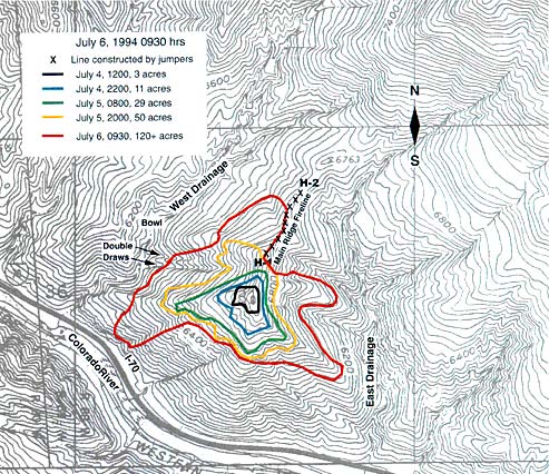
Figure 19—Fire perimeters through morning of July 6, 1994 (adapted
from original Accident Investigation Report). The 0930 perimeter is adapted
from Mackey’s map drawn during morning recon flight. The July 4
and July 5 perimeters are based on video interpretation by the Investigation
Team using Bell’s video (Bell 1994).
Flareups, small reburns, and slopovers occurred throughout the fire late
in the morning. The figure 20 photograph, taken from Interstate 70, shows
smoke from fire activity northwest of H-1 on the West Flank and also southwest
of H-1 in the area near the Double Draws. At approximately 1135 a flareup
on the West Flank Fireline ran approximately 120 feet up the slope to
the top of the Main Ridge in a narrow, about 5 foot wide, run (South Canyon
Report). This run prompted discussion to pull out of the West Flank fireline
and ignited a spot fire that the firefighters on the Main Ridge worked
to extinguish. Bucket drops of water from the helicopter cooled the flareup,
and work on the fireline resumed. In response to a flareup in a tree located
south of the Spur Ridge at about 1300, smokejumpers working near the Spur
Ridge retreated 480 feet back along the fireline to a point near the Tree
(South Canyon Report; Petrilli 1996). A water drop from the helicopter
cooled the flareup, and the firefighters returned to the area where the
fireline crossed the Spur Ridge. Smokejumper Rhoades cut down the tree
that became the Stump reference point, and the firefighters resumed building
the fireline.
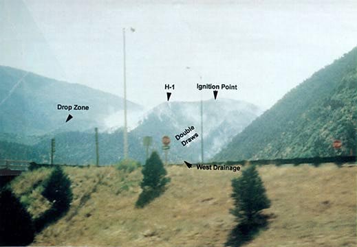
Figure 20—Photograph taken from the interstate highway looking northeast
toward west-facing side of Main Ridge. Photograph was taken by the Prineville
Hotshot Superintendent as they were traveling to the fire late on the
morning of July 6, 1994. Smoke behind light post on left is near West
Flank Fireline. Smoke behind light post on right is near the Double-Draws
Courtesy of T. Shepard
Between 1230 and 1300, the helicopter ferried 10 of the Prineville Hotshots,
including Hotshot Superintendent Shepard, from Canyon Creek Estates to
H-2. Around 1330 nine of the hotshots, led by Squad Leader Kelso, were
assigned to reinforce the smokejumpers constructing the West Flank Fireline.
Shepard remained on the Main Ridge. The remaining 10 Prineville Hotshots
remained at the helibase at Canyon Creek Estates. They noted an overcast
sky and gusty winds around 1400. Between 1400 and 1430 Hotshot Foreman
Scholz radioed Shepard three times to report gusty, erratic winds at the
helibase and increased smoke low on the fire’s west side. During
one of the calls, Shepard responded that winds had increased on the Main
Ridge.
Lunch Spot—Between 1400 and 1430 many of the hotshots
and smokejumpers working on the West Flank Fireline stopped for lunch
on a small knoll midway up the Lunch Spot Ridge (thus the name Lunch Spot).
Jumpers Thrash and Roth remained on the West Flank Fireline. At approximately
1445 Smokejumper Longanecker left to scout an area south of the Lunch
Spot Ridge. He hiked southwest from the Lunch Spot into the Double Draws
(South Canyon Report). At about 1510 Longanecker requested by radio that
some smokejumpers come down and start building line around a hotspot that
had flared up (South Canyon Report). The smokejumpers stated that they
felt some concern about building new line when the fire was still active
along the newly completed West Flank Fireline to the north. A few of the
smokejumpers moved a short distance south and east into the northeast
side of the Double Draws (see Petrilli Photo Point and Longanecker position
in fig. 8). Longanecker requested and received a water drop on the hotspot.
Witness statements indicate that as the winds increased so did the fire
activity in the underburned pinyon-juniper south of the Lunch Spot Ridge
and along the Main Ridge (South Canyon Report).
Main Ridge—Around 1515 the helicopter ferried
the remaining 10 Prineville Hotshots from Canyon Creek Estates to H-2.
They were assigned to widen the fireline on the Main Ridge between H-2
and the Zero Point. West winds between H-2 and the top of the West Flank
Fireline were strong enough that when the firefighters working on the
Main Ridge tossed brush into the air, the wind carried it over the east
side of the ridge (South Canyon Report). In contrast, about 300 feet away,
some of the group stopped for a break near the Zero Point and noted that
the winds were light, estimated to be less than 5 miles per hour (South
Canyon Report). Fire activity in the underburned oak on the west side
of the Main Ridge consisted of low intensity flaming and smoldering in
the leaves and debris on the ground under the oak canopy with some torching
of individual trees.
<<< continue
reading—Fire Behavior at South Canyon Fire, Fire
Chronology: July 6, 1530 >>>
|