 Fire
Behavior Associated with the 1994 South Canyon Fire on Storm King Mountain,
Colorado Fire
Behavior Associated with the 1994 South Canyon Fire on Storm King Mountain,
Colorado
Fire Behavior Overview
Figures 2 and 3
present a closer view of the fire location and points of interest to the
fire narrative.
Lightning ignited the South Canyon Fire on the afternoon of July 2, 1994,
on the south end of the Main Ridge. For the next 48 hours, the fire backed
down the slope in the surface litter of leaves, twigs, and grasses. The
fire behavior consisted of generally low intensity downslope spread with
occasional short duration upslope runs and torching in the Gambel oak
(Quercus gambelii) canopy and single or small groups of conifers. By 1200
on July 4 the fire had burned approximately 3 acres. It continued burning
through the day and covered approximately 11 acres by 2200.
By 0800 on July 5, the fire covered 29 acres. It continued to spread
downslope through the day on July 5, leaving many unburned islands of
vegetation. By the end of the day, the fire had burned approximately 50
acres. General fire activity consisted of low intensity downslope spread
with intermittent flareups and short duration upslope runs in the fire’s
interior. The fire remained active through the night covering approximately
127 acres by morning on July 6. Even though the fire more than doubled
in size between late evening on July 5 and the morning of July 6, its
spread rate remained consistent with that displayed during the previous
days.
On the morning of July 6 the fire continued to burn downslope through
the surface fuels with isolated torching of individual tree crowns and
short upslope runs in the fire’s interior. Flareups, small reburns,
and slopovers characterized fire activity through the late morning and
early afternoon.
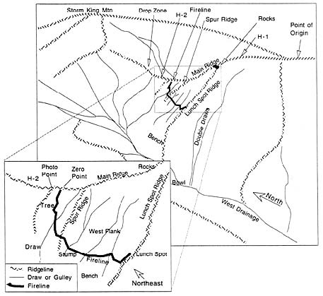
Figure
2—Oblique sketch of west-facing slope of the Main Ridge. Perspective
is looking northeast. Inset shows specific topographical features and
locations of interest to the narrative. Heavy black line is approximate
location of the West Flank Fireline (not to scale).
By midafternoon, westerly winds blowing over the tops of the north-south
oriented ridges were increasing. At approximately 1520 a dry cold front
passed over the area. Winds in the bottom of the West Drainage were estimated
to be from the south (upcanyon) at 30 to 45 miles per hour. About 1555
several upslope fire runs occurred in the grass and conifer crowns on
the west-facing slope near the southwest corner of the fire’s interior.
Some narrow upslope fire runs and flareups in the underburned oak canopy
on the upper portion of the West Flank near the Main Ridge occurred around
the same time. Shortly after the crown fire runs, witnesses observed fire
in the bottom of the West Drainage near the base of the Double Draws.
Pushed by the upcanyon winds, the fire in the West Drainage spread rapidly
north. As this fire spread north and east, fuel, slope, and wind conditions
combined to push the fire into the live Gambel oak canopy.
Firefighters on the West Flank Fireline and on the Main Ridge perceived
the fire to be burning as a wide front moving north and east up the West
Drainage and across the West Flank. We estimate that the fire moved north
up the drainage at about 3 feet per second. Steep slopes and strong west
J. Kautz, U.S. Forest Service, Missoula, MT.
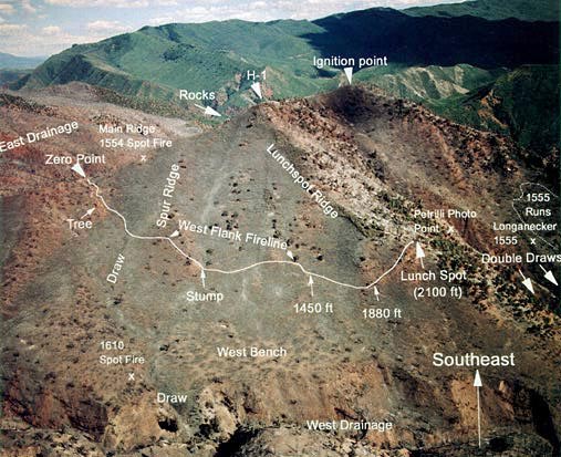
Figure
3—Aerial photograph of fire site. The perspective is looking southeast
across the West Drainage toward the West Flank. The West Flank Fireline
can be seen as a faint trail approximately in the center of the photograph.
The Lunch Spot Ridge runs from H-1 through the Lunch Spot to a point near
the bottom of the drainage. The Colorado River Gorge runs east to west
and is behind H-1 and the Ignition point. H-2 is located northeast along
the Main Ridge, off the left side of the picture.
winds triggered frequent upslope (eastward) fire runs toward the top
of the Main Ridge. These upslope runs spread through the Gambel oak at
6 to 9 feet per second (appendix B, table B-8).
The combination of steep slopes, strong winds, and flammable fuels resulted
in a fire that entrapped and killed 12 firefighters on the northeast end
of the West Flank Fireline. Two other firefighters, who moved north up
the Main Ridge then northwest toward an exposed rocky face, died in a
narrow gulley when overrun by the fire. The surviving firefighters exited
the area by moving out the East Drainage to Interstate Highway 70 along
the Colorado River.
Summary of Critical Factors Influencing the Fire Behavior
On the afternoon of July 6, 1996, the fire rapidly changed from a relatively
slow-moving fire burning downslope through the dead leaves and stems on
the ground to a fast-moving fire burning upslope through the vegetation
canopy. Some of the factors that caused the transition were fire at the
base of steep slopes containing significant areas of grass and pinyon-juniper
(Pinus edulis and Juniperus sp.), steep terrain, strong turbulent winds,
and involvement of the leaves and stems in the vegetation canopy. Following
is a brief review of these factors.
Steep, Complex Terrain—Topography was a major
contributor to the fire behavior demonstrated on July 6. Fire spread rapidly
up steep slopes. Whether ignited by burning brands lofted from a crown
fire run or simply a result of the backing fire that had burned through
the previous night and day, fire was burning near the bottom of the West
Drainage by 1555 on July 6. The presence of fire at the base of steep
slopes covered with unburned vegetation had the potential for rapid upslope
runs, even in the absence of strong winds.
Strong, Turbulent, and Variable Winds—Low level
westerly winds accompanying the cold front increased as they passed from
the relatively open and broad canyon west of the fire area into the narrow
Colorado River Gorge. The relative orientation of the West Drainage and
the Colorado River Gorge redirected a portion of the westerly winds in
the Gorge up the West Drainage. These winds caused fire growth and spotting
while pushing the fire north and east up the West Drainage. As the flank
of the fire burned up the west-facing slope it was increasingly exposed
to the westerly flow. The strong westerly winds and steep slopes caused
rapid fire runs to the Main Ridge. Therefore, the fire was spreading steadily
to the north up the West Drainage with frequent fast-moving eastward-directed
runs to the Main Ridge. This type of behavior has been termed “hook
and run.” The strong winds increased the number of spot fires and
also the spotting distance.
Involvement of Live Fuels—The relatively low intensity
fire behavior exhibited by the backing surface fire previous to the blowup
did not indicate the potential for high intensity behavior in the live
vegetation canopy. The strong updrainage winds and steep slopes caused
the flaming zone of the fire burning in the dead litter and grass to increase
in size sufficiently that the green Gambel oak canopy began burning. The
green nonburned Gambel oak carried the fire into the previously underburned
Gambel oak. The critical factors to fire spread in the vegetation canopy
were exposure to a large flaming front, steep slopes, strong winds, low
fine dead fuel moisture content, and moderately low live fuel moisture
content.
<<< continue
reading—Fire Behavior at South Canyon Fire, Fire Environment - Topography
>>>
|

 South
Canyon Fire
South
Canyon Fire