 Fire
Behavior Associated with the 1994 South Canyon Fire on Storm King Mountain,
Colorado Fire
Behavior Associated with the 1994 South Canyon Fire on Storm King Mountain,
Colorado
Fire Chronology (continued)
July 6, 1610 to 1611—Fire Below West Flank Fireline
Main Ridge—As BLM Firefighter Brixey and Smokejumpers
Doehring and Archuleta, who were hiking up the fireline from the Tree,
neared the Zero Point, the first members of the Main Ridge Group passed
them, heading toward H-2. Joining the Main Ridge Group, Archuleta, Doehring,
and Brixey continued about 110 feet north along the Main Ridge. At this
point Archuleta and Doehring moved west about 10 feet off the Main Ridge
to a location where they could see southwest diagonally down the slope
toward the fireline and lower part of the Spur Ridge. We have designated
this location the Photo Point (fig. 6 and 7).
West Flank Fireline—The West Flank Fireline group
was approaching the Draw. Hipke stated that Thrash stepped off to the
left of the fireline and said, “Shelter?” almost as a question
and Roth stepped off to the right (estimated time 1610) (Hipke 1996).
Hipke stepped past Thrash and Roth and continued a fast hike up the line.
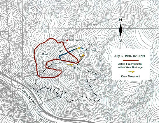
Figure 28—Fire perimeter at 1610. The fire continued to spread up
the West Drainage and east to the Main Ridge. Fire has reached top of
Main Ridge near the Rocks. Smokejumper Erickson called Smokejumper Mackey
to inform him of spot fire on north end of West Bench.
The Tree—Firefighters Haugh and Erickson remained
at the Tree, shouting and waving at the West Flank Group to hurry. Erickson
saw a spot fire on the West Bench. Later, Erickson identified the location
of the spot fire to be about 1,000 feet in distance down the slope below
the Tree and 190 feet above the bottom of the West Drainage (fig. 28).
Erickson called to inform Mackey of the spot fire (South Canyon Report).
Erickson stated, “The spot moved fast [north up the canyon]. I did
not feel a perceptible change in winds. I could tell that they [the West
Flank Fireline Group] were moving as fast as they could. At that time
the lead guy and the group were 75 yards away. We were yelling at them
to go faster. They looked tired and were not going fast. Thrash was in
the lead and Mackey was second to last. They were in a close group.”
Erickson asked Haugh to pull out his camera. As Erickson looked through
the viewfinder (about 1611) he saw the last three firefighters in the
group with fire everywhere behind them (South Canyon Report). Because
Erickson’s camera was at the end of the roll of film, this attempted
photograph had no film on which to be exposed.
Main Ridge—Archuleta and Doehring took four photographs
from the Photo Point on the Main Ridge (fig. 29a-d). Their photos show
the last three members of the West Flank Fireline Group coming over the
top of the Spur Ridge (estimated time 1611). After taking the photographs,
Doehring joined the firefighters heading north along the Main Ridge toward
H-2.
Archuleta and Doehring’s photographs show the fire burning upslope
toward the Main Ridge immediately south of the Spur Ridge. It was later
determined that these photographs were taken at essentially the same time,
angle, and view that Erickson tried to photograph (Erickson 1996). From
near H-2 Blanco called for air support from Grand Junction.
West Flank Fireline—Approximately 100 feet beyond
the point at which he had stepped past Roth and Thrash, Hipke looked back
and saw the group following 20 to 30 feet behind him with Roth in the
lead (1611). Ahead, through the brush, he could see Haugh and Erickson
at the Tree waving for them to keep coming.
The Tree—Immediately after Erickson attempted
to take the photo he turned to follow Haugh. Haugh had gone up the fireline
toward the Main Ridge and was no longer in view. Erickson looked back
over his right shoulder and saw a wall of fire coming up the hill below
the fireline (South Canyon Report). Our analysis indicates that this fire
was burning upslope on the south side of the Spur Ridge. Erickson did
not see Hipke who was climbing the fireline below him.
Witness statements and the photos taken by Archuleta and Doehring indicate
that fire extended from the West Bench 800 to 900 feet northwest of and
below the Tree, then south around the base of the Spur Ridge 400 feet
southwest of the firefighters, and up the south side of the Spur Ridge
to the top of the Main Ridge (South Canyon Report). Figures 28
and 30 show the approximate position of the fire front.
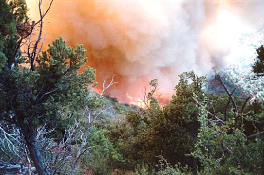
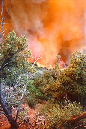
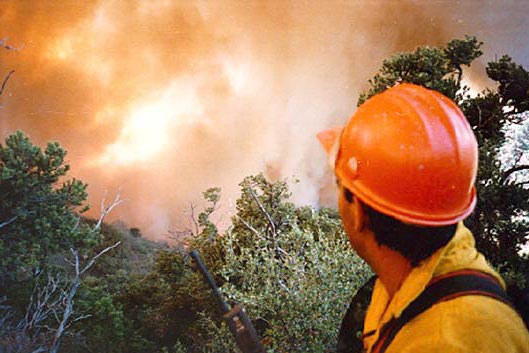
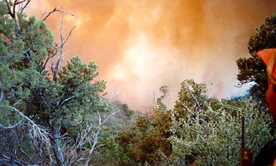
Figure 29—Photographs taken at 1611 from Archuleta/Doehring Photo
Point looking down (southwest) toward fireline and fire burning behind
the Spur Ridge. The four photographs are arranged in chronological sequence.
Courtesy of S. Archuleta and S. Doehring
<<< continue
reading—Fire Behavior at South Canyon Fire, Fire Chronology: July
6, 1611 >>>
|

 South
Canyon Fire
South
Canyon Fire