
 South
Canyon Fire South
Canyon Fire
1994
6 Minutes for Safety — 2009
Fire Behavior Report, 1998
Fire Environment
- July 2 to
Evening of July 5
- July
5, 2230 to July 6, 1530
- July 6, 1530
to 1600
- July 6, 1600
to 1603
- July
6, 1603 to 1609
- July 6, 1609
to 1610
- July 6, 1610
to 1611
- July 6, 1611
to 1614
- July 6, 1614
to 1623
- July
6, 1622 to 1830
- July
6, 1830 to July 11
References
Appendix A
Appendix B
Appendix C
|
 Fire
Behavior Associated with the 1994 South Canyon Fire on Storm King Mountain,
Colorado Fire
Behavior Associated with the 1994 South Canyon Fire on Storm King Mountain,
Colorado
Fire Chronology (continued)
July 6, 1530 to 1600—Double Draw Crown Fire Runs and Spot Fire
on Main Ridge
West Flank Fireline—At about 1530 Smokejumper
Mackey commented on the erratic winds. He sent Smokejumpers Erickson and
Doehring to patrol the West Flank Fireline for rolling material and hotspots.
The winds were increasing in speed (South Canyon Report). Mackey called
the hotshots who were working near the Lunch Spot and told them to hold
the line and improve the cup trench on the West Flank Fireline.
Main Ridge—Hotshot Scholz left the Main Ridge
and started down the West Flank Fireline carrying two 5 gallon containers
of water (time, 1530). He noted that while winds were strong and gusty
on the Main Ridge, they were relatively calm on the West Flank Fireline
(Scholz 1995).
West Flank Fireline—Jumper Hipke had left the
Lunch Spot to work on the West Flank Fireline. The Prineville Hotshots
and Smokejumpers Hipke, Thrash, Erickson, and Doehring were all working
north of the point where the fireline drops off the Lunch Spot Ridge.
We estimate that this group was spread along the fireline, approximately
1,450 to 1,880 feet down the fireline from the Zero Point (time, 1530).
Scholz, who was carrying the water containers down the line, met Roth
at the Stump. Scholz helped Roth move a log off the line (about 1539).
They talked, and then a few minutes later, Scholz headed back up the fireline
toward the Main Ridge leaving the water containers for Roth to carry to
the firefighters working farther southwest along the fireline (time, 1545).
There was little wind, and the previously cloudy sky was clearing (Scholz
1995).
Erickson and Doehring hiked north along the fireline looking for hotspots.
They met Roth at the Stump (approximately 1555).
Double Draws—After the helicopter dropped water
on a flareup in the Double Draws, Smokejumpers Petrilli, Thomas, and Shelton
contoured southeast along the slope from the Lunch Spot (approximately
1545). Another five smokejumpers were scattered between the Lunch Spot
and Petrilli, who stopped about 630 feet south and east of the Lunch Spot.
A few minutes later Longanecker asked the incoming helicopter to drop
another bucket of water on the flareup. At this time a flareup that had
occurred on the Main Ridge fireline about 200 feet south of the Zero Point
was spotting across the fireline. It was agreed that the next bucket of
water should go to the Main Ridge (South Canyon Report; OSHA 1995).
Several of the smokejumpers had gathered near what we have designated
the Petrilli Photo Point (fig. 21). From this location they could look
southwest into the Double Draws and see the area where Longanecker was
working. While the smokejumpers were at the Petrilli Photo Point, individual
trees began to torch, and a narrow crown fire started burning up the slope
located directly south across the Double Draws from them. This fire burned
through the previously underburned Douglas-fir, pinyon, and juniper with
estimated flame heights greater than 100 feet (about 1555). The smokejumpers
stopped moving downhill (South Canyon Report). Three separate runs occurred
in rapid succession (Petrilli 1996). Petrilli indicated that he and the
others with him were surprised at the speed of these runs. Petrilli photographed
this fire activity from his position (fig. 22). The photograph shows the
crown fire run and smoke over the entire area.
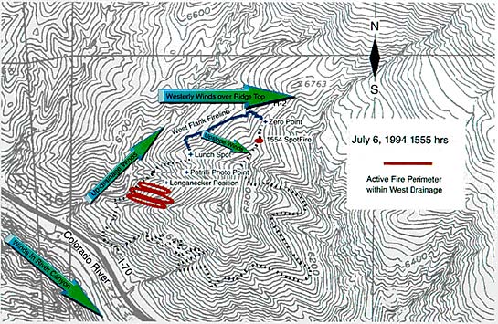
Figure 21—Topographical
map with crown fire runs in Double Draws identified by heavy red lines
(time, 1555). Vectors show general wind flow over fire area.
Main Ridge—When Scholz reached the Main Ridge,
after leaving Roth, he noted that winds were strong, approximately 45
miles per hour (time, 1553). The sky was clear over the fire, but clouds
were located over Storm King Mountain. Fire spotted across the Main Ridge
Fireline at about 1554 (fig. 23a). When Helicopter Pilot Good attempted
to drop water on the spot fire burning on the Main Ridge (around 1555),
the winds caused the water drop to miss the fire (fig. 23b). The pilot
later estimated the winds were blowing 35 miles per hour. As the pilot
flew back to refill the water bucket he noticed fire activity increasing
throughout the area (as demonstrated by increased flaming and smoking)
and saw scattered inactive spot fires on the east-facing slope across
the West Drainage north of the Lunch Spot Ridge. We believe that the spot
fires seen by Good were near the bottom of the West Drainage west of the
West Bench (fig. 24). Hearing firefighters over the radio talking about
spot fires, Good did not report those he had seen (Good 1996).
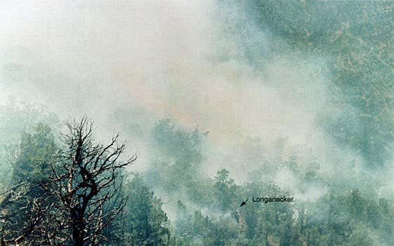
Figure 22—Photograph of smoke in West Drainage near Double Draws
at approximately 1555. Perspective is looking southwest from Petrilli
Photo Point. Smokejumper Longanecker is identified. Note flames from crown
fires burning in conifers south of the Double Draws. Courtesy
of T. Petrilli
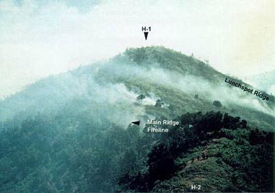
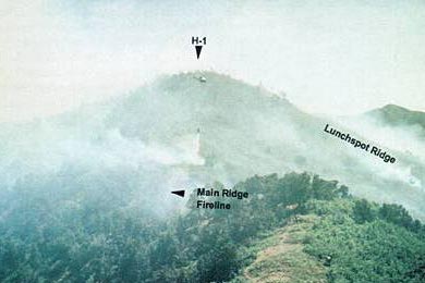
Figure 23—(A) Photograph of spot fire burning on the Main Ridge
south of the Zero Point at approximately 1553. Perspective is looking
south from knob north of H-2. (B) Photograph of helicopter dropping first
bucket of water on spot fire near Main Ridge at approximately 1555. Perspective
is looking south from knob north of H-2. Note smoke on right side of picture
over Double Draws, and winds blowing smoke and water to the left (east).
Both courtesy of T. Shepard
<<< continue
reading—Fire Behavior at South Canyon Fire, Fire
Chronology: July 6, 1600 >>>
|