
 South
Canyon Fire South
Canyon Fire
1994
6 Minutes for Safety — 2009
Fire Behavior Report, 1998
Fire Environment
- July 2 to
Evening of July 5
- July
5, 2230 to July 6, 1530
- July 6, 1530
to 1600
- July 6, 1600
to 1603
- July
6, 1603 to 1609
- July 6, 1609
to 1610
- July 6, 1610
to 1611
- July 6, 1611
to 1614
- July 6, 1614
to 1623
- July
6, 1622 to 1830
- July
6, 1830 to July 11
References
Appendix A
Appendix B
Appendix C
|
 Fire
Behavior Associated with the 1994 South Canyon Fire on Storm King Mountain,
Colorado Fire
Behavior Associated with the 1994 South Canyon Fire on Storm King Mountain,
Colorado
Conclusions
The South Canyon Fire tragically demonstrates the fire behavior that
can occur given the appropriate combination of weather, topography, fuels,
and fire. One of our most frustrating observations was that while fire
behavior during the afternoon of July 6, 1994, can be characterized as
extreme, it was normal given the environmental conditions. The fire was
a direct consequence of the fuel, weather, and topographical factors.
Similar alignments of fire environment factors and the resulting fire
behavior are not uncommon.
We have summarized the weather, fuel, and topographical information,
and presented a brief overview of the firefighter movements relative to
the fire. Using the fire environment analysis and chronology, we presented
what we believe are the most likely fire behavior scenarios.
Until the afternoon of July 6, the high intensity fire behavior consisted
of occasional short duration torching of individual trees and narrow uphill
runs in the fire’s interior. At approximately 1600 the wind, slope,
and fire location combined to result in a dramatic transition wherein
the fire began burning through the live fuel canopy as a continuous flaming
front. This report focused on the mechanisms that led to the dramatic
transition from a low intensity ground fire to a fire that was burning
through the vegetation canopy. The second part of the discussion addressed
the specific fire behavior that led to the entrapment of 14 firefighters.
We have drawn a number of discussion points from the analysis. Some of
these points will be readily apparent to firefighters. Others may be less
evident. We believe that all are important.
-
Topography can dramatically influence local wind patterns.
Surface winds in mountainous terrain are highly variable. Areas of
low or calm winds can exist while other areas experience dramatically
different wind direction, windspeed, or both. These changes can occur
without visible warning across relatively short distances, especially
when the area is subjected to large-scale weather influences such
as frontal passages. Wind information is needed from multiple locations
around the fire perimeter. This information should be communicated
to all fire personnel.
-
Vegetation and topography can reduce a firefighter’s
ability to see a fire or other influencing factors. Complex
topography and dense shrub or tree canopies can restrict the ability
of firefighters to sense, visually or otherwise, changes in wind,
fire behavior, and fire location. This emphasizes the need for adequate
observers and lookouts.
-
Current and past fire behavior often does not indicate the
potential fire behavior that could occur. Maximum possible
fire spread, flame heights, and energy release are determined by comparing
present and near-term future fuel, weather, and topography to their
state during past demonstrations of extreme fire behavior, possibly
at other fires. The fire behavior exhibited by the South Canyon Fire
from July 2 through the morning of July 6 consisted of low-intensity
downslope spread. At no time previous to the afternoon of July 6 did
it exhibit continuous high-intensity burning in the Gambel oak canopy.
Previous experience and observations of high intensity fire behavior
and training in fire environment assessment are tools that can be
used to anticipate potential fire behavior.
-
The longer a fire burns and the larger it gets, the greater
the likelihood of high-intensity fire behavior at some location around
the perimeter. Not always is a fire ignited in an ideal location
for high-intensity burning. However given sufficient time, a low-intensity
fire will often reach a position where fuel, weather and terrain combine
synergistically to produce high-intensity fire behavior. While we
have not evaluated such probabilities analytically, intuitively it
seems that the greater the range of conditions, the greater the potential
for a rapid change in fire behavior at some location along the fire
perimeter. Such was the case for the South Canyon Fire on July 6.
Knowledge about the location of a fire perimeter is necessary to adequately
assess fire potential.
-
The transition from a slow-spreading, low-intensity fire
to a fast-moving, high-intensity fire often occurs rapidly. This
seems to surprise firefighters most often in live fuels, possibly
because green vegetation is associated with reduced ignition risk.
We do not fully understand the exact mechanisms triggering these transitions.
But observations of past fire behavior indicate that such transitions
often occur when there are significant changes in windspeed or wind
direction, fire location (that is at the top of the slope versus the
base of the slope), or in the quantity of live and dead components
in the vegetation canopy. Live green vegetation can support and even
promote high-intensity burning. Monitoring fire position relative
to alignment of wind, slope, and live and dead fuels can assist firefighters
in recognizing potentially hazardous fire behavior.
-
Escape route transit time is related to both topography and
route length. Escape routes should be considered in relation
to potential maximum-intensity fire behavior rather than past or present
fire behavior. The ideal escape route includes a downhill direction
over the shortest possible distance to the safety zone, thereby maximizing
firefighter travel rates while minimizing fire spread rates.
-
The underburned Gambel oak was significant in that it did
not provide a safety zone. The blowup did not occur in the
previously underburned Gambel oak. The blowup occurred when the fire
changed from a relatively low-intensity surface fire to a high-intensity
fire burning in the canopy of the green (nonunderburned) Gambel oak
near the bottom of the West Drainage. As the fire burned up the slopes
from the nonunderburned into the previously underburned Gambel oak,
energy release rates and spread rates would have increased over their
already high values (appendix B, table B-8). Thus, the underburned
Gambel oak caused increased fire intensity as the fire burned above
the West Flank Fireline, but it was not a factor for the burning below
the fireline and therefore did not contribute significantly to the
entrapment of the 14 firefighters. However, the amount of unburned
vegetation remaining above the West Flank Fireline precluded it from
being an adequate safety zone. Firefighters do not have “one
foot in the black” when working adjacent to underburned shrub
vegetation.
-
Smoke can significantly reduce the firefighter’s abilities
to sense changes in fire behavior. This is certainly realized
by any firefighter who has had to breath smoke. There is some evidence
that the area around the fatality site was quickly engulfed in smoke
just prior to or during the burnover. The lack of a clear view of
the fire and the loud noise created by the fire would have prevented
the group from fully sensing how fast the fire was closing the gap
between it and them and may have distracted the group from their objective
of reaching safety. Their likely inability to identify the location
of the fire is one explanation for the evidence suggesting that the
group was surprised by the fire and did not realize how close the
fire was or where to go to escape it. Lookouts positioned outside
the burn area or overhead can communicate urgency and help firefighters
identify the best escape routes relative to the fire position, direction,
and rate of spread.
Our analysis emphasizes the often dramatic changes in fire behavior that
can occur when fire is exposed to steep slopes, winds, and relatively
continuous fuels. Perhaps even more important is the observation that
not all of these factors are needed, rather only one or two are needed
for a blowup to occur. None of the findings and observations discussed
in this study represent new breakthroughs in wildland fire behavior understanding.
Rather the findings support the need for increased understanding of the
relations between the fire environment and fire behavior. We can also
conclude that fire managers must continue to monitor and assess both present
fire behavior and potential future fire behavior given the possible range
of environmental factors.
During the review process, some of the reviewers commented that they
were left with a feeling of “so what” after reading the manuscript.
In fact, this is one of the points that can and should be drawn from our
study of the fire. While relatively high-intensity fire behavior was demonstrated,
it was normal and even ordinary behavior given the combination of environmental
factors. Tragically, what was not normal or ordinary was that 14 firefighters
were caught in the middle of the fire and could not escape.
As a last note to the readers, we want to say that the most difficult
task in this whole process has been achieving a balance between analysis,
calculations, and extrapolations on one end of the scale, and heartache,
feelings of loss, and even anger on the other end. Peace of mind, if at
all possible, can come only by accepting the fact that humans are part
of nature, yet understand just parts of it and master even less. Our efforts
were directed toward increased understanding, with the hope that the knowledge
gained will help to avert similar future incidents.
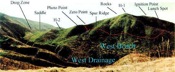
Figure 42—Panorama of the South Canyon Fire site taken 2 years after
the fire from the ridge directly west across the West Drainage from the
West Flank (Photo is a composite of two photographs
taken by T. Putnam).
|