 Fire
Behavior Associated with the 1994 South Canyon Fire on Storm King Mountain,
Colorado Fire
Behavior Associated with the 1994 South Canyon Fire on Storm King Mountain,
Colorado
Fire Environment
This section is a short summary of the fire environment on the afternoon
of July 6, 1994. First we discuss the topography. Next we discuss the
condition of the vegetation or fuels in the area. Finally, we summarize
the long-term and short-term weather related factors that influenced the
fire behavior.
For the purposes of this study, we have attempted to use the same location
names as were used in the original investigation report. However, we have
identified a few previously unnamed areas. In most cases we identify the
specific locations by a dominant geographical feature.
Topography
The fire occurred in a topographically complex area. The highest peak
in the area, Storm King Mountain, is over 8,700 feet in elevation. The
terrain south of the peak falls in a series of steep rugged broken ravines,
gullies, and ridges to the Colorado River (elevation approximately 5,680
feet). Figures 4 and 5 present an aerial photograph and topographical
map of the fire area. Figures 3, 6, 7, and 8 are aerial oblique photographs
of the fire site from different view angles.
Main Ridge—Up to the afternoon of July 6, 1994,
the South Canyon Fire burned on the southwest side of Storm King Mountain.
One of the main ridges between the mountain and the Colorado River Gorge
is locally known as Hellsgate Ridge, we refer to it as the Main Ridge.
The northeastern end of the Main Ridge begins as a saddle at the southern
base of Storm King Mountain. The two firefighters working helitack were
killed in a steep rocky chute northwest of this area. From the saddle
the Main Ridge runs to the southwest for about 3,700 feet where it abruptly
ends at the Colorado River Gorge.
Ignition Point—A lightning strike to the top of
the southwest-most knob of the Main Ridge (elevation 6,980 feet) ignited
the South Canyon Fire. To the south from the Ignition Point the terrain
falls steeply (about a 55 percent slope) to Interstate 70 and the Colorado
River.
East and West Drainages—The Main Ridge is flanked
on the east and west by two north-south oriented drainages. These drainages
are referred to as the East and West Drainages. Both drainages were formed
by erosion of the sandstone rock and soil. Fine sand fills the bottom
of the drainages with intermittent large sandstone boulders. The West
Drainage follows a twisting path north from the Colorado River Gorge.
The bottom of the West Drainage is a steep-sided (80 percent slope) ravine.
The West Drainage channeled air from the Colorado River Gorge north to
the base of Storm King Mountain. The fire changed from a backing surface
fire moving down the slope to a fast spreading fire burning upslope and
upcanyon through the shrub and tree canopies in the West Drainage. Surviving
firefighters exited via the East Drainage. The fire burned through the
East Drainage about 30 minutes after the firefighters exited it.
Lunch Spot and Spur Ridges—Two spur ridges that
are important to the narrative extend west from the Main Ridge down into
the West Drainage. The southernmost ridge, referred to as the Lunch Spot
Ridge, was where the firefighters who had been building fireline down
the West Flank of the fire ate lunch on the afternoon of July 6 (fig.
3 through 6 and 8). Eight smokejumpers deployed and survived in fire shelters
on the upper portion of the Lunch Spot Ridge during the afternoon of July
6, 1994. One smokejumper survived near the Lunch Spot without deploying
a fire shelter.
A second smaller ridge, located about 1,400 feet north of the Lunch Spot
Ridge, we call the Spur Ridge. The Spur Ridge serves as a point of reference
when discussing firefighter, helicopter, and fire location and movement.

Figure
4—Aerial overhead view of South Canyon Fire site. Note the East
and West Drainages, the Main Ridge, Interstate Highway 70, and Colorado
River Gorge. The Canyon Creek Estates subdivision is shown directly west
of the fire site. The helibase was located at the subdivision. Photo
source: Grand Junction District of the BLM, U.S. Department of Interior
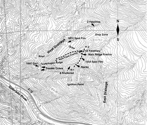
Figure 5—Topographical
map of fire area. Heavy dark dashed line identifies firelines on West
Flank and on Main Ridge. These firelines were constructed on July 6, 1994.
Helispots H-1 and H-2—Two helispots were constructed
on the Main Ridge. The first helispot (designated H-1) was constructed
on July 5 and was at the junction of the Main Ridge and Lunch Spot Ridge
at about 7,000 feet elevation on an unnamed knob. It consisted of an area
approximately 50 feet in diameter that was cleared of brush and trees.
Stumps and ground litter remained. A second helispot (H-2) was constructed
on the morning of July 6. H-2 was at 6,760 feet elevation and was about
1/4 mile north of H-1. This helispot was smaller than H-1 and was situated
in a small saddle from which the brush had been cleared away.
Double Draws—The southwest face of the Main Ridge
near H-1 falls steeply (approximately 55 percent slope) dropping more
than 1,000 feet in elevation to the bottom of the West Drainage. The Double
Draws are on this steep west-facing slope. They consist of two steep chimneylike
gullies leading into the West Drainage. They originate approximately one-third
the way down the slope below H-1 and were formed by erosion of the loose
soil (fig. 5 and 8). Several crown fire runs occurred south of the Double
Draws shortly before the fire suddenly began burning up the West Drainage
on the afternoon of July 6, 1994.
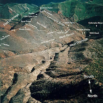
Figure 6—Aerial oblique photograph of the West Flank from a position
above the north end of the West Drainage. This photo gives a good perspective
of the Main Ridge between H-2 and H-1. J. Kautz,
U.S. Forest Service, Missoula, MT.
Bowl—A small bowl (approximately 1/2 acre) is
in the bottom of the West Drainage about 250 feet north of the intersection
of the Double Draws and the West Drainage. This area is referred to as
the Bowl. The accumulation of live and dead fuel in the Bowl contributed
to the development of the fire that spread up the West Drainage.
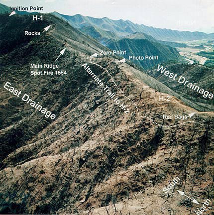
Figure 7—Aerial oblique photograph from the upper East Drainage
looking southwest. Note the nearly complete consumption of Gambel oak.
J. Kautz, U.S. Forest Service, Missoula, MT.
West Bench—Northeast of the junction of the West
Drainage and the Lunch Spot Ridge is the West Bench. This area is approximately
80 feet above the bottom of the West Drainage. The West Bench is approximately
150 feet wide and 450 feet long with the long side oriented parallel to
the West Drainage. While not flat (approximately 15 percent slope), the
West Bench is significantly less steep than the slopes on either side
of it. Gambel oak with grassy openings was the dominant vegetation on
the West Bench. Gambel oak completely covered the slopes between the West
Bench and the Main Ridge.
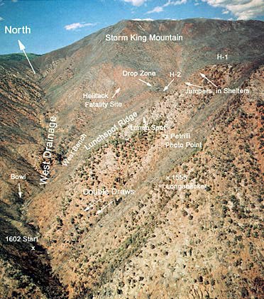
Figure 8—Aerial view of South Canyon Fire site looking north up
the West Drainage toward Storm King Mountain from a location over the
Colorado River. Note green vegetation on south side of the Lunch Spot
Ridge. J. Kautz, U.S. Forest Service, Missoula,
MT.
West Flank Fireline—This fireline is approximately
2,100 feet long with the Lunch Spot at its southernmost point. From the
Main Ridge, the West Flank Fireline leads west down the steep (about 55
percent) slope for 300 feet. From the base of this first steep pitch the
fireline continues, at a much flatter slope (about 10 percent), another
380 feet down and across the slope to the Spur Ridge. It leads over the
Spur Ridge, turns to the southwest, and follows a contour route across
the West Flank slope for about 800 feet. From this point it contours 400
feet diagonally across and down the slope, leading generally southwest,
and then climbs 200 feet up a 65 percent slope to the Lunch Spot. Several
points of interest on the West Flank Fireline are identified by their
major topographical features. Distance along the fireline from the junction
of the Main Ridge and the Fireline are given in parentheses. The points
are: the Zero Point (0 feet); the Fatality Site (120 to 280 feet); the
Tree (200 feet); the Draw at the base of the first steep pitch in the
fireline (445 feet); the Spur Ridge (680 feet); the Stump (850 feet);
two other locations (1,450 and 1,880 feet) are important to the fire chronology
presented later. All of these points are shown in figure 3. All distances
are detailed in appendix B, table B-2.
Zero Point—The junction of the Main Ridge and
the top of the fireline constructed on the West Flank is an important
geographical location when specifying specific firefighter locations and
movement. For the purposes of this report, it is referred to as the Zero
Point. We found it helpful to reference distances along the Main Ridge
and the fireline from this point. For example, helispot H-1 is 790 feet
south along the Main Ridge from the Zero Point and helispot H-2 is 560
feet north along the Main Ridge from the Zero point.
Drop Zone—The smokejumper Drop Zone was near the
Saddle on the north end of the Main Ridge (approximately 1,000 feet north
of H-2).
<<< continue reading—Fire
Behavior at South Canyon Fire, Fire Environment - Fuels >>>
|

 South
Canyon Fire
South
Canyon Fire