 Fire
Behavior Associated with the 1994 South Canyon Fire on Storm King Mountain,
Colorado Fire
Behavior Associated with the 1994 South Canyon Fire on Storm King Mountain,
Colorado
Fire Behavior Discussion
The chronology presented in the previous section describes firefighter
locations, movement, and actions. The scenario presented in the chronology
and the fire behavior analysis presented in this section represents our
best estimate of the sequence of events given the available information.
This study would be incomplete without an analysis of the physical factors
that caused the change from a relatively low-intensity, slow-moving fire,
backing downslope in the leaves and sticks on the ground, to a high-intensity,
fast-moving fire, burning through the entire vegetation complex. In the
following discussion we attempt to identify the most significant factors
leading to the dramatic transition in fire behavior.
We concentrate on two events: the blowup or transition from surface fire
to a fire burning through the shrub canopy, and the fire behavior in the
area identified as the West Flank that resulted in the entrapment and
deaths of 14 firefighters.
We identify three major factors that contributed to the blowup on the
afternoon of July 6, 1994. The first factor was the presence of fire in
the bottom of a steep narrow canyon. Second, strong upcanyon winds pushing
the fire up the canyon. Third, the fire moving into the green (not previously
underburned) Gambel oak canopy.
Fire in South End of West Drainage
The presence of fire in the West Drainage at the base of the Double Draws
is important to the later fire behavior because it places fire at the
bottom of a steep narrow canyon. After the original investigation report
was published, various theories continued to circulate regarding the source
of the fire in the West Drainage. These theories ranged from burning logs
rolling down the slope to possible arson. The available evidence most
strongly suggests that this fire originated from one or both of the following
sources: (1) fire spreading downslope through the previous night and morning
of July 6 and (2) fire brands lofted into the drainage from the crown
fire runs that occurred south of the Double Draws. We discuss both.
Witnesses report that the fire remained active through the night of July
5. On the July 6 morning reconnaissance flight, smoke was visible low
in the West Drainage. This condition continued through the day (Good 1996).
On July 2 through 6, fire burned downslope in the surface litter beneath
both Gambel oak and pinyon-juniper. The total burned area approximately
doubled each day. This rate of area growth is consistent with an approximately
constant rate of fire spread.
By midmorning on July 6 the fire had burned into the Double Draws and
was approximately 75 percent of the way down the slope between H-1 and
the bottom of the West Drainage (fig. 19). As the relative humidity dropped
and the sun heated the slopes through the day, the fire continued to spread
downhill. Photographs taken at the time of the crown fire reburn south
of the Double Draws show smoke near the bottom of the West Drainage (fig.
22).
It is easily shown that while total burned area increased exponentially,
the actual rate of spread remained remarkably constant after July 3. We
evaluated fire spread through July 6 by projecting the fire spread for
the day based on the fire area data from the previous days. The last measured
fire perimeter before the blowup was made during the morning reconnaissance
flight on July 6. Assuming continued spread at the rate exhibited during
the previous 2 days, the fire would have been within 100 feet of the bottom
of the West Drainage by 1600 on July 6 (fig. 38). The original accident
investigators estimated a downslope fire spread rate of 70 feet per hour
during the night of July 5 and early morning of July 6. Our calculations
indicate a rate of spread of approximately 32 feet per hour. While, this
analysis includes some uncertainty, it clearly supports the possibility
that fire reached the bottom of the West Drainage by 1600 on July 6, 1994.
The downhill spread, the location of the fire at midmorning, and the presence
of smoke relatively low in the West Drainage make it probable that the
fire reached a point in or near the bottom of the West Drainage by early
afternoon.
Fire spotting occurs when burning embers are lofted into the air by the
buoyant smoke column above a flame, carried by the wind, and then redistributed
on the ground causing new fire starts. Short distance fire spotting occurred
throughout the day on July 6, 1994, as individual trees
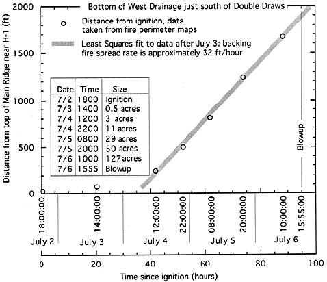
Figure 38—Projected
fire location on afternoon of July 6, 1994, based on fire perimeter maps
from previous days. The fire spread distances were estimated measuring
the distance down the slope on a line running from a point midway between
the ignition point and H-1 to a point in the bottom of the West Drainage
just to the south of the Double Draws. A least squares linear approximation
was then fitted to the data after July 3; this is represented by the heavy
shaded line. All distances are increased by 14 percent (assumes 55 percent
slope) to account for the actual distance down the slope. The burned area
data are included in the table shown in the figure. Dates and some critical
times are also shown on the horizontal axis to assist the reader in relating
fire growth to the chronology.
burned and the fire made short runs. Given the wind flow patterns in
the West Drainage, it is probable that a shear layer formed where the
upcanyon (southerly) flow met the westerly flow blowing over the ridges
(fig. 16 and 39). Smoldering and burning embers lofted into this turbulent
air mass by the crown fire south of the Double Draws would have been distributed
generally northward along the bottom of the West Drainage. The original
investigators reported 90 to 100 percent probability of ignition based
on information from area National Fire Danger Rating System Stations.
Witness statements and later interviews suggest that the attention of
the smokejumpers was focused on the crown fire runs rather than the source
of smoke farther down the slope. However, shortly after the crown fires
south of the Double Draws, the smokejumpers saw fires starting to burn
actively near the bottom of the east-facing slope across the West Drainage
(Petrilli 1996). This suggests that burning embers from the crown fires
may have ignited the fire in the bottom of the drainage.
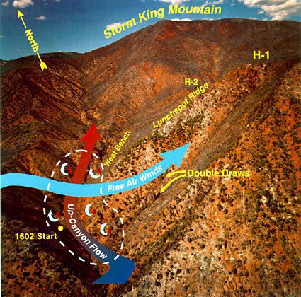
Figure 39—Schematic
showing interaction of westerly flow over ridgetops and northerly flow
up bottom of West Drainage forming a shear layer (dashed line). The turbulence
generated by this shear layer enhanced the spread of burning embers up
the West Drainage and surface wind turbulence in the area of the Double
Draws and the West Bench. J. Kautz, U.S. Forest
Service, Missoula, MT.
While it is not possible to identify with absolute certainty the exact
ignition mechanism for the fire in the bottom of the West Drainage, the
evidence suggests that the fire resulted from one or a combination of
the two mechanisms discussed above.
Winds Push Fire into Bowl
Relying on witness statements and fire behavior knowledge, we suspect
that the area identified as the Bowl contributed to the blowup on the
afternoon of July 6. Postfire investigation of the site revealed nearly
complete consumption of the surface fuels in the Bowl. Scorch marks caused
by increased burning on the north side of the trees in this area suggest
the presence of strong upcanyon (southerly) winds during the fire. We
surmise that the concentration of debris on the ground carried the fire
into the crowns of the conifers in the Bowl. This increased the size and
height of the convection column over the fire. Several witnesses observed
the smoke column build rapidly over the area identified as the Bowl. We
believe that strong vertical momentum associated with the fire in the
Bowl lofted embers up and onto the slopes on both sides of the drainage
(South Canyon Report). These embers ignited spot fires.
Fire Transitions to Gambel Oak Canopy
General wind direction and topography caused the fire to spread up the
West Drainage. Witness statements support this. Pushed by the winds up
the steep slopes, the fire burned past the junction of the Lunch Spot
Ridge and West Drainage and up onto the West Bench (see fig. 4).
Although the fire area was exposed to wind on July 4, 5, and 6, the Gambel
oak canopy did not sustain continuous fire spread, even in previously
underburned areas. As the fire burned downslope in the litter fuel beneath
the pinyon, juniper and oak canopies, it was generally sheltered from
the wind by the vegetation canopy. Upslope fire spread was confined to
unburned islands within the fire perimeter or initiated by ladder fuel
concentrations under individual trees (for example, the tree on the West
Flank Fireline that became the Stump). Significant change in fire behavior
occurred only after fire burned into fine fuels at the base of steep slopes
and was exposed to strong winds. Such a transition occurred on the west-facing
slope south of the Double Draws where the surface fire burned into the
conifer crowns spreading upslope in several high-intensity crown fire
runs.
Following the crown fire runs, the fire burned in litter and cured grass
fuels along the bottom of the West Drainage spreading up the steep east-
and west-facing slopes and up the West Drainage past the Lunch Spot Ridge
onto the south end of the West Bench. The vegetation canopy was less dense
on the east-facing slopes and along the West Bench. This exposed the surface
fire to the strong winds. The steep slopes and exposure to strong winds
resulted in significant increases in the size of the flames and energy
release rates. This resulted in ignition of the pinyon-juniper canopy
on the east-facing slopes and the green Gambel oak canopy on the West
Bench. The following discussion focuses on the physical mechanisms that
resulted in the fire spreading into and through the live fuel canopy as
a continuous fire front.
The mechanisms driving the transition from surface to crown fire are
not fully understood. In general, fire in the vegetation canopy follows
an increase in the amount of energy entering the canopy, or a decrease
in the amount of energy necessary to ignite the complex, or both. Increased
slope, wind exposure, or decreased moisture status of live or associated
dead fuels may individually, or in combination, result in such transitions.
Fire spread from the surface into the vegetation canopies often occurs
rapidly; however, the factors leading up to the transition may develop
relatively slowly. For example, fires often burn downslope relatively
slowly, but when a backing fire reaches a position where an upslope run
in unburned fuels is possible, the transition from backing to a fast-moving
upslope fire may happen suddenly. Another example is fire burning through
an area where it is sheltered from the wind into a location where it is
more exposed to wind. The increased wind exposure can lead to a sudden
change in fire behavior with little or no apparent change in the environment.
In both of these examples the fire burned from one area to another resulting
in an abrupt change in the slope or wind exposure. Solar heating can also
influence the tendency for a fire to spread into the vegetation canopy.
Exposure to the sun can cause a decrease in relative humidity and subsequent
decreases in dead fuel moisture levels. This effect may occur both under
and within the live vegetation complex. Decreased fine dead fuel moisture
reduces the amount of energy needed for ignition. This drying may occur
throughout the day or, as in the examples above, be caused by the fire
burning into a sun-exposed aspect. When the fire reaches an area of drier
fine dead fuel, the flaming zone can increase in size and intensity, again
leading to sustained combustion in the vegetation canopy.
When a fire begins burning in the vegetation canopy, the flaming zone
often significantly increases in height and depth. This increase is linked
to the overall increase in total burning fuel load and decrease in bulk
density (mass of fuel per unit volume). Increased fuel load leads to larger
flames and energy release. Decreased bulk density often results in faster
fire spread rates (Catchpole and others 1998). These two factors contribute
to sustained burning in the live vegetation.
Another factor contributing to fire spread in vegetation canopies is
live fuel moisture content. In an effort to assess the impact of fuel
moisture on the blowup of the South Canyon Fire, we compare the conditions
present on the Battlement Creek and South Canyon Fires.
A high intensity fire run occurred on the Battlement
Creek Fire on July 17, 1976. This fire was approximately
30 miles west of the site of the South Canyon Fire, both burned in similar
terrain and vegetation. The live Gambel oak foliar moisture content at
the Battlement Creek Fire
was 167 percent (USDI 1976). A killing frost on June 14, 1976, followed
by dry weather significantly increased the quantity of fine dead fuel
in the oak canopy over historical levels. Surface winds were light and
consisted of normal upslope convective flow characteristic of summertime
conditions in the area. Winds aloft were 5 to 15 miles per hour from the
southwest. Slopes ranged from 10 percent near the bottom to 75 percent
near the ridgetop. The fire burned on slopes that were generally west-facing
and fully exposed to solar heating from about 1100 (USDI 1976).
In contrast, the Gambel oak at the South Canyon Fire site was not frost
damaged, and consequently the canopy did not contain an abnormally high
amount of dead leaves and stems. However, low precipitation levels during
the previous 8 months had pushed the area into an extreme drought. Green,
nonunderburned Gambel oak vegetation was sampled on July 12, 1994, at
two sites located east of the South Canyon Fire area. The sites were at
a similar aspect and elevation to the area identified as the West Flank.
The measured live fuel moisture contents were 125 percent. The live fuel
moisture content would not have changed significantly between July 4 and
July 12, 1994. The West Flank was west-facing with 10 to 60 percent slopes
and was exposed to solar radiation from about midmorning. The South Canyon
Fire site was exposed to strong winds on July 4 and 5, 1994, and for some
time prior to and during the blowup on July 6.
Both the Battlement and the South Canyon Fires experienced similar flame
sizes, energy release, and spread rates. Fire reaching the base of steep
slopes was the triggering mechanism to ignition of the canopy at the Battlement
Creek Fire. Large quantities of dead matter in the otherwise
relatively high live moisture canopy contributed to fire spread into the
canopy on the steep slopes. Strong winds were not a contributing factor.
In contrast, the transition in fire behavior on July 6, 1994, on the South
Canyon Fire can be linked to strong winds pushing the surface fire into
fuels of sufficient quantity that the green Gambel oak began burning.
Sustained fire spread through the green Gambel oak canopy was supported
by steep slopes, wind, and moderately low live fuel moisture. Crown fire
spread continued with reportedly much reduced windspeeds on the steep
slopes of the West Flank Fireline. Once the canopy was ignited, the increase
in energy release rates substantially contributed to continued crowning
on both the Battlement Creek and the South Canyon Fires. It was only after
the fire began burning in the nonunderburned green Gambel oak that it
spread into the previously underburned Gambel oak.
Conclusions based on only two samples cannot be considered definitive.
But this comparison suggests that sudden transitions from surface fire
to fire in live vegetation canopies can be linked to a combination of
factors, including but not limited to: live and dead vegetation moisture
content, the spatial distribution and quantity of live and dead components
in the canopy, exposure to wind, fire site aspect and slope, and the intensity
of an initiating fire burning within, adjacent to, or under the vegetation
canopy. Not all of these factors are necessary for a surface fire to spread
into the vegetation canopy.
<<<
continue reading—Fire Behavior at South Canyon Fire, Fire Behavior
Discussion: West Flank>>>
|

 South
Canyon Fire
South
Canyon Fire