 Fire
Behavior Associated with the 1994 South Canyon Fire on Storm King Mountain,
Colorado Fire
Behavior Associated with the 1994 South Canyon Fire on Storm King Mountain,
Colorado
Fire Behavior Discussion (continued)
Fire on West Flank
As the fire burned through the bottom of the West Drainage, up onto the
Bench, and up the slopes, it was influenced by two windflow patterns:
the upcanyon (southerly) flow in the bottom of the West Drainage and the
westerly flow associated with the passing cold front. There is strong
evidence in the form of witness observations, photographs (fig. 35), and
postfire meteorological modeling to support the existence of strong upcanyon
winds in the West Drainage. These winds pushed the fire up the drainage.
As fire burned along the bottom of the West Drainage, it spread up onto
the West Bench where it began burning in the Gambel oak canopy. Once the
fire burned above the Bench, it was increasingly exposed to the westerly
winds blowing across the north-south oriented ridges. The result was short
duration rapid fire runs east to the top of the Main Ridge. The fire was
essentially spreading in two directions, one front moving northeast and
one front east (fig. 27). It was the first series of the eastward runs
that caused the firefighters moving south along the Main Ridge toward
H-1 to turn around at the rocks and retreat back toward H-2.
Our analysis suggests that the fire was spreading north, up the canyon,
at approximately 3 feet per second. Spread rates of 7 feet per second
occurred on midslope runs and northeast directed runs between Erickson’s
Spot Fire and H-2. We estimate that the upslope runs from the West Bench
to the Main Ridge occurred at a rate of 6 to 9 feet per second (see table
B-8).
Although there were no eyewitnesses to the fire event in which 12 firefighters
perished on the West Flank Fireline near the tree, the available information
suggests three possible fire behavior scenarios. They are presented below.
We believe the three scenarios represent the most likely events. The actual
sequence of events may have included parts of all three scenarios. We
also discuss the fire behavior that resulted in the deaths of the two
helitack crewmembers. Finally, we address the possibility of a fuel-air
explosion.
One scenario, referred to as the “U” shaped fire front, involves
fire burning on three sides of the firefighters as they started up the
last section of the fireline. A second scenario, termed the surfacing
smoke column, is based on the assumption that strong westerly winds blowing
across the top of the north-south oriented ridges pushed the column of
smoke and hot gases against the slope. This simultaneously ignited the
vegetation over a relatively wide area around the firefighters. A third
scenario simply assumes that the fire on the West Bench below the firefighters
ignited a rapid upslope run. This run, assisted by westerly winds, burned
quickly up the Draw, overtaking the group of firefighters hiking up the
fireline.
The fire conditions and events last observed and recorded by witnesses
in the area of West Flank Fireline are common starting points for all
three scenarios. The following is a short review of those conditions and
observations.
At approximately 1608:30 BLM Firefighter Haugh and Smokejumper Erickson
were at the Tree. They heard the fire roar as it burned into the previously
underburned Gambel oak near the 1,450 foot mark on the West Flank Fireline.
Haugh and Erickson then saw firefighters coming up the fireline where
it passes over the top of the Spur Ridge. The fire on the West Bench was
starting to catch up to the crew hiking up the fireline. Erickson called
Smokejumper Mackey to warn him of the fire approaching from behind the
Spur Ridge. There was no noticeable wind at the Tree, but the firefighters
could see wind pushing the flames and smoke on the east-facing slopes
across the West Drainage from them.
As the firefighters on the West Flank Fireline came closer (about 500
to 550 feet below the Zero Point) Erickson saw a bearded McCall Smokejumper
(Roth) in the lead. There was a yellowish glow over the West Bench. Erickson
also recognized Mackey, who was the second person from the end as the
group came over the Spur Ridge. Erickson then saw a spot fire appear directly
below and west of him. He later located this spot fire on the West Bench
near the West Drainage and about 75 feet north of the small draw that
runs directly up the slope towards the Tree (fig. 40). Almost instantly
the spot started to grow and Erickson called Mackey on the radio and warned
him of the spot fire (about 1610:30). Erickson then took out his camera
to take a picture of Mackey near the end of the oncoming firefighters.
His camera was out of film.
At about 1611, Archuleta and Doehring, who were at the Photo Point located
on the Main Ridge and north and east of Erickson, took a series of four
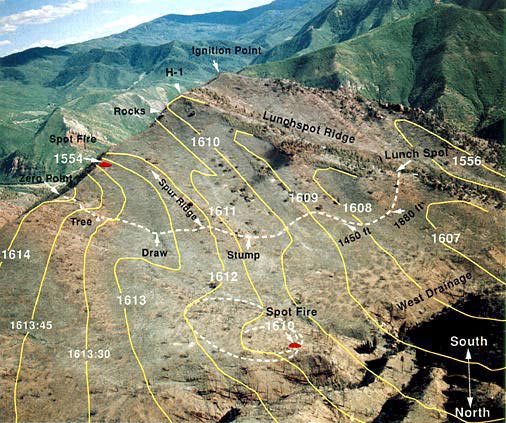
Figure 40—Approximate
fire perimeter positions between 1607 and 1614 on July 6, 1994. These
perimeters are estimated from reconstruction of events, firefighter movements
and witness statements. As such, the perimeters are subject to some uncertainty.
J.
Kautz, U.S. Forest Service, Missoula, MT.
photographs. The first two photos show the last three West Flank Firefighters
before they disappeared into the Draw 445 feet down the fireline from
the Zero Point. Haugh, Erickson, Archuleta and Doehring all report that
the fire behind the Spur Ridge roared as it crossed the fireline. Our
analysis indicates that this occurred near the Stump. The fire burned
quickly up the slope to the top of the ridge. We later determined from
the photos that at this time the northeastern edge of the fire on the
West Bench was about 200 feet south of the Draw and directly below the
Tree. The West Bench fire had been advancing in a hook and run or “J”
pattern, and the bottom edge of the “J” was now 200 to 300
feet from Erickson’s spot fire. Erickson said the sky was all orange
and the spot fire was growing rapidly as he turned and headed up the fireline
toward the Zero Point (time, 1611:15). This was the last observation about
the fire below the West Flank Firefighters and leads into our three most
probable scenarios.
At this time (1611:15) both the leading edge of the West Flank Fire and
the spot fire could have been the source for the fire that burned east
up the slope and overran the 12 firefighters and a short time later H-2.
Erickson’s spot fire quickly merged with the main fire and continued
burning toward H-2 and the saddle below the Drop Zone. The fire coming
through the saddle below the Drop Zone cut the two helitack crewmen off
from the East Drainage.
“U”-Shaped Fire Front—As one moves
northeast from the area where Erickson saw the spot fire, the vegetation
changes from predominantly Gambel oak to pinyon-juniper and grass with
some scattered Douglas-fir. The conifers and grass extend up the slope
to the Photo Point. Erickson said that fire on the east-facing slopes
(covered mostly with pinyon-juniper and grass) was more advanced than
the fire on the west-facing slopes. This suggests that the fire was spreading
faster in the pinyon-juniper and grass than in the oak. This is consistent
with observations from other fires. As the spot fire observed by Erickson
spread into the grass and pinyon-juniper, it moved northeast up the slope
reaching a point on the Main Ridge approximately 100 feet north of the
Zero Point. This fire could have been the source of the heat felt by Robertson
and Archuleta as they traveled north along the Main Ridge directly east
of the Photo Point.
When the West Flank Fireline Group neared the draw at the base of the
last steep pitch in the fireline, the main fire front was 450 feet west
and 400 feet southwest of them (about 1612). Fire extended up the south
side of the Spur Ridge to the Main Ridge, around the bottom of the Spur
Ridge, across the Draw below the Tree, and partially up the slope below
the Photo Point. The fire burning up the slope in the pinyon-juniper and
grass north of them may have been even closer.
This suggests that by 1613 the fire front formed a “U” or
concave shape with the West Flank Fireline Group in the middle (fig. 40).
From a physical perspective, such a “U” shaped fire front
is inherently unstable. The unburned area within the concave fire front
received heat from three sides rather than one. The presence of fire on
multiple sides increased the amount of energy incident on the vegetation
around the firefighters. This caused rapid ignition and fire spread up
the last section of the fireline. The sequence of rapid preheating, ignition,
and fire spread would likely have been perceived by the firefighters,
especially those in the lower portion of the West Flank Fireline Group,
as nearly instantaneous ignition of the vegetation around them. Movement
of air in front of the fire as it ignited a large area and accelerated
up the fireline could have been the source of the blast of hot air felt
by Hipke. It could also have caused convective heating followed by radiant
heating as the flames progressed up the slope.
Doehring and Archuleta’s photographs and Erickson’s observations
place fire below the West Flank Fireline Group. The wind, slope, and vegetation
combined to result in the fire spreading rapidly north up the West Drainage
and east to the top of the Main Ridge. The sequence of fire perimeters
shown in figure 40 would have been essentially the same in all cases presented
in this report.
Surfacing Smoke Column—A turbulent gust associated
with strong westerly winds pushing against or through the smoke column
is an alternate source for the blast of air that hit Hipke. This assumes
that fire was burning up the south side of the Spur Ridge and northeast
up the West Drainage directly west of the West Flank Fireline Group. It
is possible that the strong west winds blowing across the tops of the
north-south oriented ridges pushed the column of smoke and burning gases
against the slope around the firefighters. As the gust hit the slope it
carried hot air, smoke, and embers. Evidence suggests that smoke existed
in sufficient quantities to impair their breathing, vision, or both. The
embers and hot air enhanced preheating, ignition, and fire spread around
the firefighters hiking up the fireline. Firefighters breathing in the
hot gases were quickly incapacitated.
As Hipke hiked up the last 80 feet of the fireline and crossed over the
Main Ridge, he suffered burns although he was attempting to shield his
ears and face with his hands. The most severe occurred on his right side
and back, with some lesser injury to his left side. Hipke states that
the burns occurred shortly before and during the blast of hot air. Neither
Hipke nor Erickson remember seeing flames nearby when they exited the
fireline and crossed over the Main Ridge. If the column of hot air and
smoke above the fire was pushed against the slope, convective heating
would have occurred before the vegetation ignited. Radiant heating would
have followed. It is also possible that smoke could have obscured the
firefighter’s view of flames in the area while not fully shielding
them from the radiant heat emitted by the flames. While they do not recall
seeing flames near the Zero Point, the lack of fire at the top of the
ridge, and Hipke’s testimony about the blast of air, lend some support
to the possibility that the smoke column surfaced against the slope.
General Upslope Spread—While the West Flank Fireline
Group hiked up the lower portion (south of the Spur Ridge) of the fireline,
they were moving in the same general direction as the fire (predominantly
north). The fire was spreading north up the West Drainage at about 3 feet
per second while the firefighters were moving at 4 to 5 feet per second.
As the group passed the Stump and started up and over the Spur Ridge their
rate of travel slowed to less than 2 feet per second. After crossing the
Spur Ridge, the fireline turns eastward upslope to the Main Ridge. While
the path between the point where the fireline crests the Spur Ridge and
the Draw is not steep, the footing was rough and uneven due to the multiple
oak stobs along the ground. We estimate that the firefighters traveled
between 3 and 4 feet per second. Of even greater importance is the relative
direction of travel. As the firefighters hiked over the Spur Ridge and
started along the last segment of the fireline, their direction of travel
relative to the fire’s major direction of spread changed. They were
moving generally east, while the fire was spreading generally northeast.
Thus, as the group passed the Stump, the distance separating them and
the fire began to decrease.
As the crew moved through the Draw and started up the last and steepest
section of the West Flank Fireline their rate of travel decreased to between
1 and 3 feet per second. The fire spread upslope as fast as 9 feet per
second.
Between 2 and 3 minutes elapsed between the time the first members of
the West Flank Fireline Group passed the Draw until they were caught by
the fire. We plotted the high and low estimated fire spread rates against
the rate of firefighter movement for the period 1607 to 1614. Figure 41
presents these data. Our analysis indicates that when the first members
of the West Flank Fireline Group neared the Draw (time, 1610), the fire
was approximately 450 feet south and southwest of them. By 1611 the fire
was directly below them.
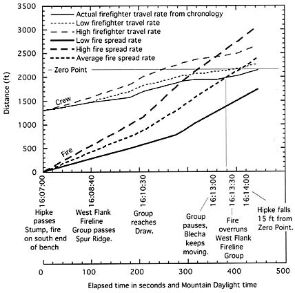
Figure 41—Time/distance
diagram depicting the speed and distance covered by the firefighters hiking
up the last portion of the West Flank Fireline versus that for the fire.
The data used for this figure were obtained from appendix B. The high
and low firefighter travel rates were obtained by actual reenactments
by two physiologically different adult males (see table B-4). Note that
the actual speed of the West Flank Fireline Group was slower than the
lowest reenacted values. The fire spread rates are approximate values
taken from table B-8.
Using crew travel rates taken from the chronology and the average fire
spread, we estimate that the fire reached the firefighters at 1613:15.
Figure 41 illustrates the speed with which the fire caught and overburned
the firefighters. In the previous sections we presented two scenarios
by which the fire caught and overran the firefighters. This analysis suggests
general fire spread up the Draw below the last section of the West Flank
Fireline could have overrun the firefighters: a third scenario. The blast
of hot air felt by Hipke could have been associated with the expansion
of air in front of the fire as it quickly spread up the slope.
Helitack—After leaving H-2, the two helitack crewmembers
moved along the top of the Main Ridge, moving generally north, perhaps
in an attempt to reach the Drop Zone where they hoped to meet the helicopter.
As the fire burned eastward across the saddle, it would have blocked the
helitack crewmembers from following the others out the East Drainage.
Possibly in an effort to reach an outcropping of rocks, the two firefighters
continued northwest. They died in the bottom of a steep narrow gulley.
The gulley would have acted as a chimney, channeling hot gases and smoke
up the slope to their location about a minute after they entered the gulley.
Contributing Factors—Each of the three proposed fire scenarios
provide some explanation for the rapid entrapment of the crew and the
blast of hot air felt by Hipke. Witness statements indicate that the firefighters
were aware that the fire was burning as a wide front behind them. There
has been some question why the firefighters did not increase their rate
of travel or did not drop their gear to exit the area more quickly. We
have not addressed psychological or emotional factors in this report,
but leave that topic for future analyses.
Other factors reduced the ability of the firefighters to fully identify
the location of the fire. Postfire evidence did not indicate an organized
attempt by the group to deploy their fire shelters. This suggests that
the group was surprised by the fire. As the firefighters hiked up the
West Flank Fireline they could see the fire from some selected locations
(for example, Hipke saw the fire below them from a location near the Stump).
However, much of the time, the 6 to 12 foot high oak brush hindered their
view of the fire. The smoke in the air further reduced the ability of
the firefighters to see the fire. Witnesses state the noise from the fire
was as loud as that produced by a train or jet airplane.
It is likely that the area around the fatality site was quickly engulfed
in smoke just prior to or during the burnover. The lack of a clear view
of the fire and the loud noise created by the fire would have prevented
the group from fully sensing how fast the fire was closing the gap between
it and them. Their likely inability to identify the location of the fire
is one explanation for the evidence suggesting that the group was surprised
by the fire and did not realize how close the fire was or where to go
to escape it.
We suspect that the “U” shaped fire front occurred. However,
we also believe it likely that the strong westerly winds pushed the column
of hot air and smoke against the slope. Our analysis suggests that general
upslope fire spread was two to three times faster than the firefighters’
upslope travel rates.
Fuel-Air Explosion—Hot air, smoke, and burning
embers hit Smoke-jumper Hipke 15 feet west of the Zero Point; he jumped
and fell forward. When he stood up he had to raise his hands to continue
to shield his face from the heat. He was burned on his back and sides
with some indication of slightly more severe burning on his right side
(Hospital Report 1994). The hot air blast originated from behind him.
There has been considerable discussion as to the source of the blast of
air. In fact, this evidence raised questions about the possibility of
a fuel-air explosion over the West Flank Fireline. The other factor suggesting
a fuel-air explosion is the apparent suddenness with which the fire overran
the 12 firefighters on the West Flank Fireline. The firefighters were
burned while still in line, many with their packs still on, and only a
few showed signs that they had tried to deploy their fire shelters.
We do not believe that a fuel-air explosion occurred. This theory assumes
that combustible gases accumulated in sufficient concentration to result
in an explosion. Although several firefighters testify that winds on the
West Flank Fireline were calm, we believe that strong winds and turbulence
existed in the air above the fireline. This turbulence, the general instability,
and the topography lead us to believe it unlikely that combustible gases
could have accumulated in sufficient concentrations to support an explosion.
<<< continue
reading—Fire Behavior at South Canyon Fire, Conclusions >>>
|

 South
Canyon Fire
South
Canyon Fire