
 South
Canyon Fire South
Canyon Fire
1994
6 Minutes for Safety — 2009
Fire Behavior Report, 1998
Fire Environment
- July 2 to
Evening of July 5
- July
5, 2230 to July 6, 1530
- July 6, 1530
to 1600
- July 6, 1600
to 1603
- July
6, 1603 to 1609
- July 6, 1609
to 1610
- July 6, 1610
to 1611
- July 6, 1611
to 1614
- July 6, 1614
to 1623
- July
6, 1622 to 1830
- July
6, 1830 to July 11
References
Appendix A
Appendix B
Appendix C
|
 Fire
Behavior Associated with the 1994 South Canyon Fire on Storm King Mountain,
Colorado Fire
Behavior Associated with the 1994 South Canyon Fire on Storm King Mountain,
Colorado
Fire Chronology (continued)
July 6, 1600 to 1603—Fire Crosses West Drainage
Main Ridge—Short duration torching and runs through
the vegetation canopy were occurring inside the fire perimeter. The BLM/U.S.
Forest Service firefighter crew on the Main Ridge had been working to
extinguish the spot fire located about 200 feet south along the Main Ridge
from the Zero Point. The spot fire continued to burn on the east side
of the Main Ridge Fireline (1600). The wind was strong enough that it
blew Crewmember Byers hardhat off (South Canyon Report). Scholz called
the Prineville crew members working on the Main Ridge Fireline near H-2
to move up (south) to help the BLM/U.S. Forest Service crew working on
the spot fire.
Double Draws—A few minutes after the crown fire
runs south of the Double Draws, Petrilli saw smoke coming from the bottom
of the West Drainage (1602). Fire was starting to burn north up the east-facing
slope across the drainage from him (South Canyon Report; Petrilli 1996).
Petrilli radioed Mackey about the fire across the drainage. Then he and
the smokejumpers with him started back toward the Lunch Spot. The fire
in the West Drainage quickly developed into a running flaming front 50
yards wide burning diagonally up the east-facing slope and up the West
Drainage (South Canyon Report) (fig. 24). Petrilli estimated that winds
at his location were blowing 35 miles per hour (time 1603). Longanecker
heard a call for retardant (he thought it came from Mackey). The person
making the call stated, “We have a real bad situation here”
(South Canyon Report). Longanecker began moving toward the Lunch Spot,
which he had identified as a safe area.
July 6, 1603 to 1609—Fire Moves Up West Drainage
West Drainage—The winds blowing up the bottom
of the West Drainage pushed the fire quickly through the fine fuels into
the Bowl (about 350 feet north from the base of the Double Draws). Postfire
inspection suggests that the Bowl contained a heavier concentration of
vegetation than on the surrounding slopes. As the fire burned into the
cured grasses, small shrubs, and standing live and dead trees in the bowl,
the size and height of the smoke column over the fire increased.
Lunch Spot—The smokejumpers, who had been observing
the fire in the Double Draws, continued back to the Lunch Spot (about
5 minutes walking time). The fire on the east-facing slope across from
them ran 770 feet to the top of the ridge and continued to burn north
along the slope. Smokejumper Petrilli estimated the upslope winds at his
location were blowing about 45 miles per hour (Petrilli 1995).
West Flank Fireline—Smokejumper Hipke, who had
been working on a hotspot about 100 feet north along the West Flank Fireline
from the Lunch Spot, moved farther north around the hotshots in front
of him and continued up the fireline (generally toward the northeast).
He met Smokejumper
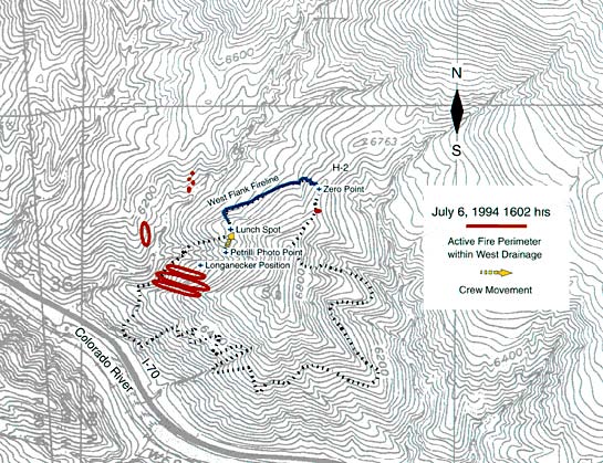
Figure 24—Topographical map showing fire south of Double Draws and
starting to burn across the bottom of the West Drainage and toward the
Bowl (approximate time, 1602). Red dots in West Drainage indicate approximate
locations of inactive spot fires based on helicopter pilot Goods statements.
Thrash at about 1603. Within a minute, Thrash and Hipke were joined by
Smokejumper Roth, who had come down the line carrying the two water containers
Hotshot Scholz had left with him. About 1604, Smokejumpers Hipke, Roth,
and Thrash, and Hotshot Hagen, who was nearby, noticed the smoke column
building over the West Drainage. After a short discussion the four of
them started hiking northeast up the West Flank Fireline toward the Main
Ridge. It appeared to them that the area around the Double Draws and Lunch
Spot would be overrun first, so moving north up the West Flank Fireline
was the only alternative (Hipke 1995). At the same time, Hotshot Kelso,
who was working on the West Flank Fireline between Thrash and the Lunch
Spot, radioed Shepard to inform him that “a spot fire [had] crossed
the draw [West Drainage] below them” (South Canyon Report). Shepard
told them “to get out of there” and go to the designated safety
zone at H-1 (Scholz 1995; South Canyon Report). Kelso and the other hotshots
working on the fireline were also moving northeast up the fireline by
the time the three smokejumpers and Hagen started out the fireline (about
1605).
Main Ridge—Noting the increased activity on the
Main Ridge, the incoming helicopter, the strong winds, and Kelso’s
call, Scholz commented, “Things are getting complicated.”
Shepard and Blanco told the Main Ridge Group to go to H-1 (South Canyon
Report; OSHA 1995). Hotshot Gray noted the time on his watch as 1604 and
commented, “Remember this time” (South Canyon Report; Scholz
1995). Scholz told his group to wait for the incoming bucket drop (Scholz
1995). Many spot fires had developed on the Main Ridge. The firefighters
who had been working on the Main Ridge abandoned their efforts to control
them (Scholz 1995).
Helicopter Pilot Good estimates he was flying through westerly winds
of 45 to 50 miles per hour on his return with the second bucket of water
for the Main Ridge spot fire. Due to strong westerly winds, he had to
circle around and approach the Main Ridge from the east. This time he
hit the spot fire with the water drop (about 1605). The water cooled the
spot fire sufficiently (fig. 25) for the firefighters to pass through
it and move south, uphill toward H-1. As Good finished the water drop
and started back to refill the bucket, he noted the large smoke column
building over the Bowl. The smoke was blowing directly over his position
above the Main Ridge. He was not able to see into the base of the column
from his position. However, recognizing the change in the situation, he
headed to the helibase at the Canyon Creek Estates subdivision to disconnect
the bucket so he could return to ferry firefighters off the ridge (Good
1996).
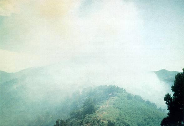
Figure 25—Photograph taken shortly after the second water drop on
Main Ridge at approximately 1601. Perspective is same as in figures 23a
and b, looking south from top of knob north of H-2. Note column developing
over West Drainage and significantly more smoke over west flank of fire
than shown in photograph taken from same point approximately 10 minutes
earlier. Courtesy
of T. Shepard
Lunch Spot—Mackey and the other smokejumpers who
had been with Petrilli met on the Lunch Spot Ridge about 100 feet below
the Lunch Spot. The smokejumpers were moving toward the Lunch Spot. Mackey
told them there was a good “black” area farther up the Lunch
Spot ridge and to go there. As the smokejumpers continued up the ridge,
Mackey called to check on Longanecker’s position. Longanecker replied,
“We’re in a safe zone” (1606) (South Canyon Report).
After leaving the eight smokejumpers, Mackey continued across West Flank
behind the hotshots and smokejumpers who were hiking up the West Flank
Fireline to the Main Ridge.
West Flank Fireline—As Smokejumpers Hipke, Roth,
and Thrash neared the Stump, Hipke looked back to the southwest and saw
fire burning in the bottom and up both sides of the West Drainage, the
fire front was advancing north and was forming a “U” shape
in the bottom of the West Drainage (fig. 26) (Hipke 1994).
The Tree—Jumpers Doehring and Erickson met Smokejumper
Archuleta near the Draw (450 feet below and west of the Zero Point). Archuleta
had walked down the fireline from the Main Ridge. They moved up the fireline
to the Tree located 200 feet below the Zero Point where BLM Firefighters
Brixey and Haugh were working with a chain saw (1606). Brixey and Haugh
shut off their saw. The three smokejumpers pointed out the smoke column
over the West Drainage and relayed the message to move to the safety zone.
Following a short discussion Archuleta, Doehring, and Brixey headed up
the fireline toward the Main Ridge (1608). Erickson and Haugh remained
at the Tree (South Canyon Report).
<<< continue
reading—Fire Behavior at South Canyon Fire, Fire
Chronology: July 6, 1609 >>>
|