
 South
Canyon Fire South
Canyon Fire
1994
6 Minutes for Safety — 2009
Fire Behavior Report, 1998
Fire Environment
- July 2 to
Evening of July 5
- July
5, 2230 to July 6, 1530
- July 6, 1530
to 1600
- July 6, 1600
to 1603
- July
6, 1603 to 1609
- July 6, 1609
to 1610
- July 6, 1610
to 1611
- July 6, 1611
to 1614
- July 6, 1614
to 1623
- July
6, 1622 to 1830
- July
6, 1830 to July 11
References
Appendix A
Appendix B
Appendix C
|
 Fire
Behavior Associated with the 1994 South Canyon Fire on Storm King Mountain,
Colorado Fire
Behavior Associated with the 1994 South Canyon Fire on Storm King Mountain,
Colorado
Fire Environment
Weather
Long Term—The South Canyon Fire Investigation
report states that “weather significantly contributed to the blowup
of the fire.” Below normal precipitation (as compared to the 30
year average) during the winter and spring of 1994 had pushed western
Colorado into a severe drought (South Canyon Report). Precipitation levels
at Glenwood Springs from October 1, 1993, through July 6, 1994, were 58
percent of normal. Accompanying the below-normal precipitation were much
warmer than normal temperatures through May and June. This pattern persisted
into July. Fires in western Colorado during the previous weeks had exhibited
rapid spread rates and long range spotting, both characteristic of drier
than average conditions.
July 5, 1994—On this day, weak high pressure aloft
and a hot, dry air mass covered western Colorado. Upper level winds were
light from the southwest through 14,000 feet and then increased to 30
miles per hour at 16,000 feet. At Grand Junction, CO, the lower atmosphere
was dry and unstable as indicated by a Haines Index of 6 (Haines 1988).
That morning a strong cold front developed in western Idaho. The front
was associated with an unseasonably cold upper level low pressure system,
centered over northern Oregon. By late afternoon the cold front extended
from eastern Idaho into central Nevada.
We are not aware of any weather observations taken by firefighters working
on the fire. The closest remote automatic weather station (RAWS) was southwest
of the airport at Rifle, CO, approximately 10 miles west of the fire site.
We assume that the measurements from Rifle are representative of the conditions
over the South Canyon Fire.
Between 0100 and 0600 on July 5 the relative humidity at the Rifle RAWS
ranged from 10 to 40 percent. Relative humidity remained near 11 percent
until after midnight (fig. 11). Winds at the Rifle RAWS were light and
variable through the morning and late afternoon of July 5, 1994 (fig.
12). By 1800 on July 5, 1994, winds over the South Canyon Fire area were
blowing generally from the south at 10 to 15 miles per hour with gusts
to 20 miles per hour (South Canyon Report; Bell 1994).
July 6, 1994—At 0600 this day, the cold front
extended from central Wyoming across northwest Colorado into southwestern
Utah (fig. 13). Relative humidity at Rifle reached a high of 29 percent
at about 0700 as compared to 40 percent the previous date (fig. 11). The
lower relative humidity during the early hours of July 6 enhanced burning
during the night. This is supported by witness statements that the fire
was more active through the night on July 5 than on previous nights.
The front passed over Grand Junction around 1300 and caused the 10 to
15 mile per hour winds to increase to approximately 30 miles per hour
(South Canyon Report). The front passed over the Rifle RAWS station between
1400 and 1500, as indicated by increased winds out of the west-southwest.
They reached their peak at about 1600 with gusts to 45 miles per hour.
The relative humidity at Rifle reached a minimum of 8 percent at 1700
on July 6. The winds at Rifle changed to the northwest at 1900. They gradually
decreased through the evening and were blowing less than 6 miles per hour
by 2300 (fig. 12).
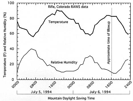
Figure 11—Temperature and relative humidity measurements from the
Rifle, CO, Remote Automatic Weather Station for period midnight on July
5, 1994, through 2300 on July 6, 1994.
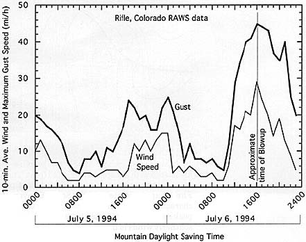
Figure 12—Wind speeds from the Rifle, CO, Remote Automatic Weather
Station for period midnight on July 5, 1994, through 2300 on July 6, 1994.
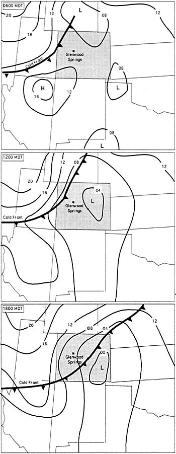
Figure 13—Surface air pressure charts showing progression of cold
front on July 6, 1994 (taken from original Accident Investigation Report).
Firefighters on the fire and at Canyon Creek Estates, a residential subdivision
about 2 miles west of the fire, noted an increase in winds between 1400
and 1430 (Scholz 1995). We surmise these were prefrontal winds associated
with the approaching cold front. The Accident Investigation Team meteorologist
estimated that the cold front passed over the South Canyon Fire at approximately
1520 (South Canyon Report). Witness statements characterized the winds
as continuing to increase in speed, reaching their peak strength shortly
after 1600. The original investigation report estimated southerly winds
in the West Drainage of 20 to 35 miles per hour and westerly winds blowing
across the ridges of 45 miles per hour at this time. Statements made by
firefighters and the helicopter pilot suggest that it is likely that gusts
over 50 miles per hour occurred in the chimneys and saddles along the
ridges. Smokejumpers near the Lunch Spot at 1606 estimated upslope winds
of 30 to 45 miles per hour (Petrilli 1995). Winds over the fire area remained
strong until 2000 (South Canyon Report).
Topography and Wind—There is inconsistent testimony
in witness statements regarding winds in the area of the fire. While the
general flow was from the west, the direction and intensity of the winds
varied significantly from one location to another (South Canyon Report;
Shepard 1995). For example, firefighters working on the Main Ridge stated
that as they cleared away brush from the fireline they could throw it
into the air and the wind would carry it over the side of the ridge. At
nearly the same time firefighters working on the northeast portion of
the West Flank Fire Line (a location topographically sheltered from the
wind) and at an exposed rocky outcropping near H-1 stated they experienced
almost no wind at all. Though inconsistent with each other, these observations
are consistent with the character of surface winds in complex mountainous
terrain, particularly when influenced by strong, synoptic-scale weather
patterns.
We feel topography was particularly influential on the surface winds
the afternoon of July 6. West of the fire site the Colorado River flows
through a relatively open and broad canyon. The low level westerly winds
accompanying the cold front passed through this canyon. The canyon narrows
dramatically about 2 miles west of the mouth of the West Drainage then
opens to the east near Glenwood Springs (fig. 7 and 14). As the wind flowed
from the broad canyon into the narrow Colorado River Gorge it increased
in speed (fig. 15).
Several factors combined to create unusually strong upcanyon flow in
the bottom of the West Drainage. First was the topography near the mouth
of the West Drainage. The orientation of the ridge running from the ignition
point, west to the Colorado River, acted as a “scoop” redirecting
a portion of the westerly flow in the Colorado River Gorge northward up
the bottom of the West Drainage (fig. 4 and 5). Second, normal daytime
heating of the upper slopes in the West Drainage induced general upcanyon
flow. This upcanyon flow resulted in a low pressure region at the entrance
to the West Drainage, causing even more air to flow from the gorge into
the drainage. Third, the increasingly strong westerly winds associated
with the cold front evacuated air from the top of the West Drainage (fig.
16). This resulted in pressure-induced flow from the Colorado Gorge into
the West Drainage. Some photographs and video footage taken during the
blowup show smoke movement (Bell 1994) and clearly illustrate the complexity
and turbulence of the surface winds shortly after 1610. High resolution
meteorological modeling (see appendix C) supports the mesoscale wind analysis
by the Accident Investigation Team meteorologist.
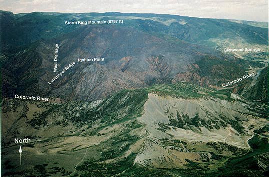
Figure 14—Aerial oblique photograph looking north over the Main
Ridge and Storm King Mountain from the south side of the Colorado River.
Note the widening of the river gorge as it opens into Glenwood Springs.
While not shown in this picture, the Colorado River Gorge again widens
to the west (off left side of photograph) of the fire site.
J. Kautz, U.S. Forest
Service, Missoula, MT.
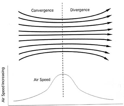
Figure 15—Schematic diagram of venturi effect that caused increased
local winds where the West Drainage meets the Colorado River Gorge (not
to scale).
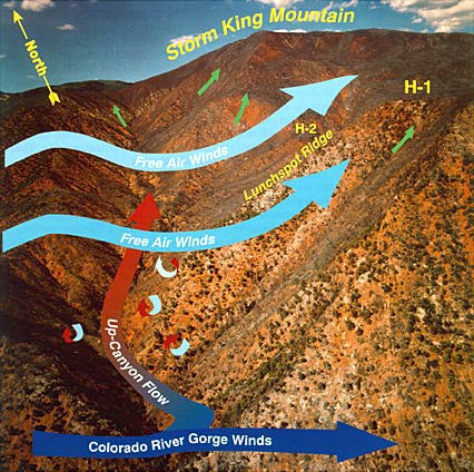
Figure 16—The general air flow over the fire area at the time of
the crown fire runs south of the Double Draws (about 1555). The free air
westerlies (light blue) evacuate the afternoon upslope flow (green) out
of the upper end of the West Drainage. This creates an area of divergence
in the north end of the West Drainage. The topography and orientation
of the mouth of the West Drainage redirected a portion of the strong winds
in the Colorado River Gorge (dark blue) up the West Drainage (red). A
shear zone is created where the westerly winds interact with the flow
up the West Drainage. Turbulent eddies created by the shear zone may have
enhanced burning near the Double Draw and along the Lunch Spot Ridge and
West Bench. The eddies transported burning embers north up the West Drainage.
J. Kautz, U.S. Forest Service, Missoula, MT.
<<< continue
reading—Fire Behavior at South Canyon Fire, Fire Chronology >>>
|