
 South
Canyon Fire South
Canyon Fire
1994
6 Minutes for Safety — 2009
Fire Behavior Report, 1998
Fire Environment
- July 2 to
Evening of July 5
- July
5, 2230 to July 6, 1530
- July 6, 1530
to 1600
- July 6, 1600
to 1603
- July
6, 1603 to 1609
- July 6, 1609
to 1610
- July 6, 1610
to 1611
- July 6, 1611
to 1614
- July 6, 1614
to 1623
- July
6, 1622 to 1830
- July
6, 1830 to July 11
References
Appendix A
Appendix B
Appendix C
|
 Fire
Behavior Associated with the 1994 South Canyon Fire on Storm King Mountain,
Colorado Fire
Behavior Associated with the 1994 South Canyon Fire on Storm King Mountain,
Colorado
Fire Chronology (continued)
July 6, 1614 to 1623—Helitack Firefighters Overrun
As the fire approached H-2, Helitack Crewmembers Browning and Tyler headed
toward the smokejumper Drop Zone located about 1,000 feet to the northeast
(South Canyon Report). The helicopter pilot tried to make radio contact
with the two helitack crewmembers; he could not see them and they did
not respond to his radio calls. The high winds, air turbulence, smoke,
and the approaching fire forced the helicopter to leave the area. Firefighters
entering the East Drainage radioed and yelled for the two helitack crewmen
to follow them down the drainage (OSHA 1995). Tyler and Browning replied
that they needed to go up the hill—to “run the ridge”
(OSHA 1995). It is not clear where the two firefighters were headed. Perhaps
they felt the East Drainage to be unsafe, or they expected to be picked
up by the helicopter that was flying over H-2 at this time.
Fire quickly engulfed the entire Main Ridge from the Rocks near H-1 to
the smokejumper Drop Zone. A portion of the fire ran northeast across
the saddle between H-2 and the Drop Zone, cutting the two helitack crewmen
off from the East Drainage (fig. 33). This fire caused the firefighters
below H-2 to turn and go straight down the East Drainage rather than follow
a contour route toward the northeast (South Canyon Report; OSHA 1995).
The helitack crewmembers were forced by the fire to go northwest from
the Drop Zone toward a bare rocky outcropping. As they neared the rocky
face, they encountered a 50 feet deep gulley. Evidence gathered during
the postfire inspection suggests that after entering the gully, they set
their gear down and moved about 30 feet down the gully where they attempted
to deploy their fire shelters. Based on a reenactment of the travel time
between the red bags near H-2 and the helitack fatality site, we estimate
that the two firefighters reached the gulley and attempted to deploy their
shelters between 1622 and 1623 (fig. 34). The postfire evidence suggests
that the two firefighters, Robert Browning and Richard Tyler, were incapacitated
and died when they were engulfed in hot air and smoke before they could
fully deploy and enter their fire shelters.
East Drainage—Blanco, Shepard, and Scholz followed
the Main Ridge Group down the East Drainage (approximately 1614 to 1615).
They arrived at the Interstate between 1715 and 1730 (Scholz 1995).
July 6, 1622 to 1830—Smokejumpers Deploy in
Shelters on Lunch Spot Ridge
Lunch Spot Ridge—The eight smokejumpers hiking
up the Lunch Spot Ridge reached their shelter deployment site at approximately
1619. They deployed in two groups, six nearest H-1 and two a short distance
farther down the ridge. The deployment area had burned in previous days
and was a short distance (235 to 430 feet) below the junction of the Main
Ridge and Lunch Spot Ridge (H-1). Smokejumper Petrilli called Mackey over
the radio about 1619 but did not receive a response. Petrilli checked
his watch as they entered their shelters; the time was 1624. Over the
next 45 minutes the eight smokejumpers felt heat from three separate fire
runs that occurred about 500 feet south of them (Petrilli 1996).
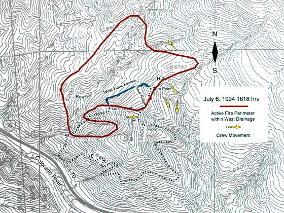
Figure 33—Fire perimeter at 1618. Fire is burning along the Main
Ridge from H-1 to the Smokejumper Drop Zone. It is also burning northeast
across the saddle, cutting Helitack Crew-members Tyler and Browning off
from East Drainage (1618).
Following Blanco’s call for support, airtankers were dispatched
to the fire from Grand Junction. They were off the ground around 1630
and were over the fire within 20 minutes. High winds and heavy smoke prevented
the planes from getting near the fire. Photos and video (Bell 1994) taken
from the heliport at the Canyon Creek Estates subdivision at about this
time show a large smoke column building over the entire West Flank (fig.
35). The pilots spotted the shelters of the eight firefighters who deployed
on the Lunch Spot Ridge below H-1 and dropped retardant around the deployment
site (fig. 36). Smoke totally obscured the slopes north of the Lunch Spot
Ridge. Because the smoke and high winds showed no signs of quickly abating,
the airtankers were released (South Canyon Report).
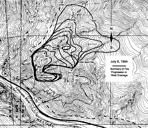
Figure 34—Fire perimeters from blowup (1602) to 1623.
Longanecker, who had hiked up the Lunch Spot Ridge, joined the eight
smokejumpers near the top of the Lunch Spot Ridge as they emerged from
their shelters (1800 to 1830). The fire had almost totally consumed the
Gambel oak on the entire west-facing slope of the Main Ridge, leaving
scattered, burned stobs. The area was cool enough to cross on foot, and
the smokejumpers began looking for the other firefighters. Seeing objects
that looked out of place with the surroundings near the top of the West
Flank Fireline, some of the smokejumpers walked over to the area. There
they found 12 firefighters who had died in the fire. After notifying the
authorities of the fatalities, the nine smokejumpers hiked to H-2 to wait
for the helicopter to ferry them off the mountain.
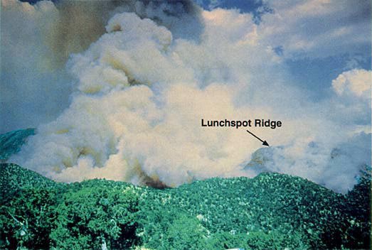
Figure 35—Photograph taken from Canyon Creek housing subdivision
looking east at smoke column. Note that the smoke columns show both the
upcanyon winds above the West Drainage and the west winds blowing across
the ridges. Courtesy of C. Johnson
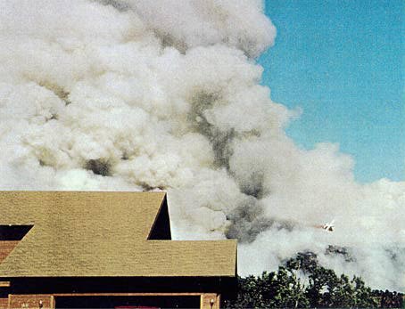
Figure 36—Photograph taken from Canyon Creek Subdivision looking
east at tanker plane dumping fire retardant near eight smokejumpers deployed
on upper portion of the Lunch Spot Ridge.
Courtesy of W. Williams
July 6, 1830 to July 11—Search and Rescue,
and Fire Burns to Glenwood Springs
Archuleta, who had hiked out the East Drainage, joined 28 smokejumpers
at the helibase at Canyon Creek Estates (directly west of the fire site).
About 25 of the smokejumpers were ferried by helicopter to the Main Ridge
to continue search and rescue operations. On the return trips, the helicopter
ferried the smokejumpers who had sheltered on the Lunch Spot Ridge back
to the helibase. Those searching for the two missing helitack crewmembers
walked out the West Drainage after dark. The bodies of the two helitack
crewmen were found on July 8, 1994.
The fire continued to spread eastward toward Glenwood Springs covering
approximately 2,000 acres by nightfall. Maps of the fire perimeter made
on July 10 indicate that the fire had burned about 2,115 acres (fig. 37).
The fire was declared controlled on July 11, 1994.
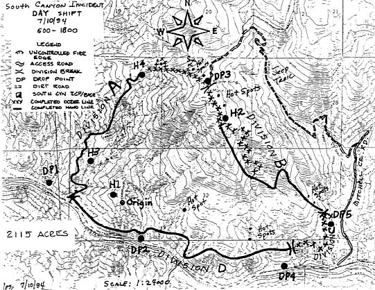
Figure 37—South Canyon Fire Day Shift Fire Map for July 10, 1994.
This map shows the approximate final fire perimeter and fire size of 2,115
acres.
<<<
continue reading—Fire Behavior at South Canyon Fire, Fire Behavior
Discussion >>>
|